GLOSS Station Handbook – Hadera
The GLOSS Station Handbook is currently being re-designed and upgraded.
Until a new version is available, the tide gauge station list below from the last version of the Handbook provides links to further details about each tide gauge in the GLOSS Core Network. Click column headings to sort the station list table. Click the GLOSS number buttons to view the station information.
Station information
| General | |
|---|---|
| Gloss number | 80 |
| Station name | Hadera |
| Country | Israel |
| Time zone | 000E, GMT |
| Latitude (+ve N) | 32.46666 |
| Longitude (+ve E) | 30.88333 |
| Ocean | Mediterranean |
| Observation periods | 1992- |
| Responsible country | Israel |
| Authority responsible for tide gauge | Nat.Inst.of Oceanography, Israel Oceanographic and Limnological Research, P.O. Box 8030, Tel Shikmona, Haifa 31080, Israel |
| GLOSS contact | Israel |
| Committed to GLOSS | Yes |
| Operational | Yes |
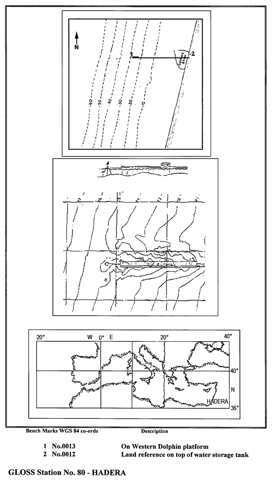
| Location map | |
| Instrumentation | |
| Float | No |
| Pressure | Yes |
| Bubbler | No |
| Acoustic | No |
| Radar | No |
| Data | |
| Digital data | Yes |
| Additional parameters | Sea/air temp., currents, waves, atmospheric pressure, winds |
| Data acquisition rate | Sea elevation recorded at constant intervals 128 times/hour. Filtered to hourly values by arithmetic. |
| Real-time data available | Yes |
| Additional parameters (real-time) | None |
| Benchmarks | |
| Tide gauge benchmark | 0013: Dolphin point (32 28N, 34 52E), stainless steel, epoxy coated bolt on dolphin concrete capping platform. Elevation (H) of benchmark & local undulation (N) are 6.187m and 34.786m respectively (WGS-84 datum). |
| Benchmark relationships | Data are referenced to the zero of the land survey datum of Israel. Tide gauge zero (TGZ) = 18.00m below TGBM 0013. TGZ = 11.50m below Israel Land Survey Datum |
| Auxiliary benchmarks | 0012: Land control benchmark (32 28N, 34 53E), on top of water storage tank, H=16.132m, N=34.821m. Height difference from 0012 to 0013 (1991) orthometric diff.=9.945m, ellipsoidal diff.=9.980m; (1993) ellipsoidal diff.=9.983m. Three other precise levelling points in Israel Land Survey Network (0745, 0746 and 4462) are located nearby. |
| Data at PSMSL | |
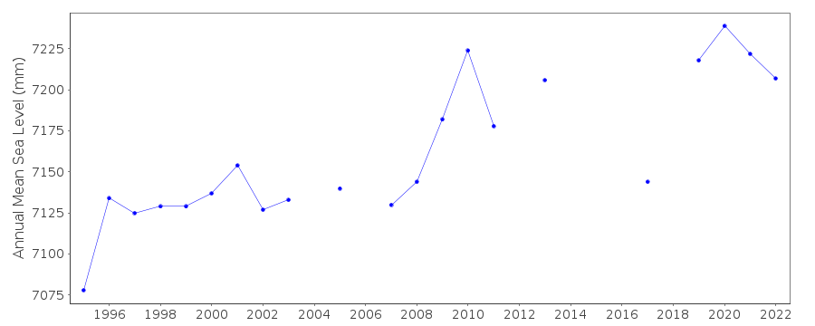
| Annual MSL (RLR) data | RLR 1797 |
| Annual MSL (RLR) plot | |
| MSL method | Arithmetic average |
| PSMSL code | 1797 |
| Additional information | |
| Other relevant information | The dolphin used was loaded in 1980 with 900 metric ton for soil resistance testing & is estimated to have reached complete consolidation. The location of the Hadera station is estimated by some local geologiststo have been stable for the past 2000 years, on the basis of available geological data. |
| Nearest Met. station | Hadera Port, Israel |
| Last updated | 28 November 1993 |
Location map
Hadera, Israel
Real time data plot
Hadera, Israel