GLOSS Station Handbook – Port Elizabeth
The GLOSS Station Handbook is currently being re-designed and upgraded.
Until a new version is available, the tide gauge station list below from the last version of the Handbook provides links to further details about each tide gauge in the GLOSS Core Network. Click column headings to sort the station list table. Click the GLOSS number buttons to view the station information.
Station information
| General | |
|---|---|
| Gloss number | 76 |
| Station name | Port Elizabeth |
| Country | South Africa |
| Time zone | 030E, GMT + 2hrs |
| Latitude (+ve N) | -33.57 |
| Longitude (+ve E) | 25.37 |
| Ocean | Indian |
| Observation periods | 1937- |
| Responsible country | South Africa |
| Authority responsible for tide gauge | Hydrographer, South African Navy, Private Bag X1, Tokai 7966, South Africa |
| GLOSS contact | South Africa |
| Committed to GLOSS | Yes |
| Operational | Yes |
| Instrumentation | |
| Float | Yes |
| Pressure | No |
| Bubbler | No |
| Acoustic | Yes |
| Radar | Yes |
| Data | |
| Digital data | Yes |
| Additional parameters | Sea temperature (from 1990), air pressure (from 1990) |
| Data acquisition rate | Float/stilling well - filtered hourly. Acoustic meaned values recorded at one minute intervals. |
| High frequency data at BODC | Data 076 Document 63864 |
| High frequency data at UHSLC | Data 184a Document 184a File format |
| Real-time data available | No |
| Additional parameters (real-time) | None |
| Benchmarks | |
| Tide gauge benchmark | Trig Survey BM PE1 adjacent bollard No. 1 Charl Malan Quay. UTM Grid Reference 35 HLN 732417. |
| Benchmark relationships | Tide Gauge Zero (TGZ) = South Africa Chart Datum. TGZ = 0.838m below LLD (MSL) until 31 December 1978 TGZ = 0.900m below LLD (MSL) from 01 January 1979 TGZ = 5.299m below BM PE1 |
| Data at PSMSL | |
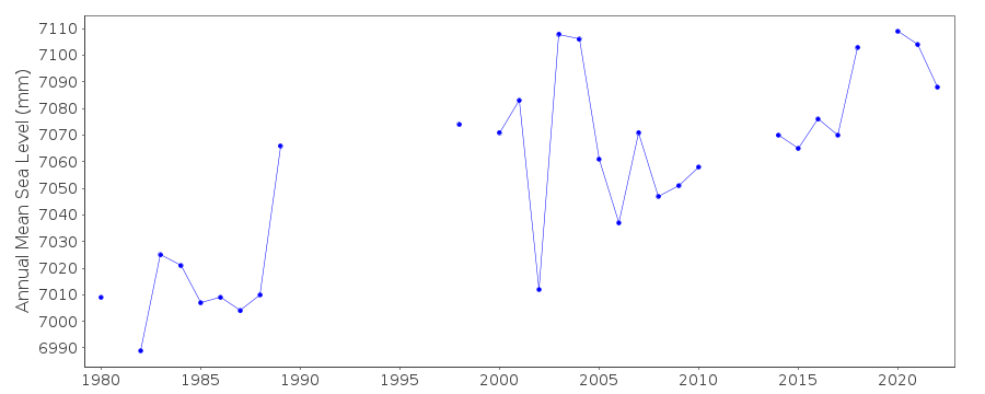
| Annual MSL (RLR) data | RLR 820 |
| Annual MSL (RLR) plot | |
| MSL method | Doodson X0 filter |
| PSMSL code | 820 |
| Other relevant codes | UHSLC 184 |
| Additional information | |
| Other relevant information | Values based on GPS have been observed but not finally calculated. |
| Nearest Met. station | Port Elizabeth |
| Last updated | 11 December 2002 |
Real time data plot
Port Elizabeth, South Africa