GLOSS Station Handbook – Rabaul
The GLOSS Station Handbook is currently being re-designed and upgraded.
Until a new version is available, the tide gauge station list below from the last version of the Handbook provides links to further details about each tide gauge in the GLOSS Core Network. Click column headings to sort the station list table. Click the GLOSS number buttons to view the station information.
Station information
| General | |
|---|---|
| Gloss number | 65 |
| Station name | Rabaul |
| Country | Papua New Guinea |
| Time zone | 150E, GMT + 10hrs |
| Latitude (+ve N) | -4.2 |
| Longitude (+ve E) | 152.18333 |
| Ocean | Pacific |
| Observation periods | Dec 1974- |
| Responsible country | U.S.A. |
| Authority responsible for tide gauge | Dr. M. Merrifield, University of Hawaii, Dept. of Oceanography, 1000 Pope Road MSB 307, Honolulu, Hawaii 96822, U.S.A. |
| GLOSS contact | Papua New Guinea |
| Committed to GLOSS | Yes |
| Operational | Yes |
| Location map | |
| Instrumentation | |
| Float | Yes |
| Pressure | No |
| Bubbler | No |
| Acoustic | No |
| Radar | No |
| Data | |
| Digital data | Yes |
| Data acquisition rate | 15 minute intervals |
| Fast delivery data at UHSLC | Data 010 File format |
| High frequency data at BODC | Data 065 Document 57253 |
| High frequency data at UHSLC | Data 010a Document 010a File format |
| Real-time data available | Yes |
| Additional parameters (real-time) | None |
| Benchmarks | |
| Tide gauge benchmark | BM RL 303 A Department of Lands and Survey brass plate, with pin, stamped 'RL No 303' at the north east corner of the old copra, north of Wreck Wharf, 300 yards from tide gauge. |
| Benchmark relationships | Tide Gauge Zero (TGZ) = 2.996m below TGBM (Apr 1978) Chart Datum = 3.057m below US C&GS BM 1 Chart Datum = 1.503m below 'Moresby 1941' benchmark |
| Auxiliary benchmarks | BM RL 431 A Dept. of Lands & Survey brass plate with pin, stamped 'RL No 431', at the corner of Malaguna Road and Coastwatchers Road, north west side of centre island along top of curbing. UH-1 A stainless steel disc 1.25 inches in diameter set in white epoxy, established by the Oceanography Dept., University of Hawaii, 4 foot north of tide staff, at centre of the curb, on Main Wharf. |
| Data at PSMSL | |
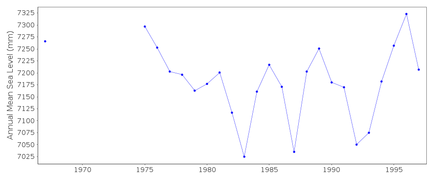
| Annual MSL (RLR) data | RLR 1164 |
| Annual MSL (RLR) plot | |
| PSMSL code | 1164 |
| Other relevant codes | UHSLC 010, NTF port no. 56200 |
| Additional information | |
| Other relevant information | Other benchmarks: US C&GS BM 1 A standard brass US C&GS benchmark, marked 'No.1 1948', set in the top of a low stone wall at the seaward end of Namanula Street. Moresby BM 1941 The centre of a standard RAN hydrographic Branch circular brass triangulation plate marked 'HMAS Moresby 1941', set into a stone seawall by the swimming pool at the seaward end of Namanula St. |
| Last updated | 16 October 2002 |
Location map
Rabaul, Papua New Guinea
Location map
Rabaul, Papua New Guinea
Location map
Rabaul, Papua New Guinea
Real time data plot
Rabaul, Papua New Guinea