GLOSS Station Handbook – Carnarvon
The GLOSS Station Handbook is currently being re-designed and upgraded.
Until a new version is available, the tide gauge station list below from the last version of the Handbook provides links to further details about each tide gauge in the GLOSS Core Network. Click column headings to sort the station list table. Click the GLOSS number buttons to view the station information.
Station information
| General | |
|---|---|
| Gloss number | 52 |
| Station name | Carnarvon |
| Country | Australia |
| Time zone | 120E, GMT + 8hrs |
| Latitude (+ve N) | -24.9 |
| Longitude (+ve E) | 113.65 |
| Ocean | Indian |
| Observation periods | 1965- |
| Responsible country | Australia |
| Authority responsible for tide gauge | WA Department of Transport, Marine Division, PO Box 402, Fremantle, WA 6160, Australia |
| GLOSS contact | Australia |
| Committed to GLOSS | Yes |
| Operational | Yes |
| Instrumentation | |
| Float | Yes |
| Pressure | No |
| Bubbler | No |
| Acoustic | No |
| Radar | No |
| Data | |
| Digital data | Yes |
| Additional parameters | None |
| Data acquisition rate | 5 minute samples |
| High frequency data at UHSLC | Data 167a Document 167a File format |
| Real-time data available | No |
| Additional parameters (real-time) | None |
| Benchmarks | |
| Tide gauge benchmark | Peg 13, the top of a section of rail set in concrete between locomotive rails about 10 metres east of the abutment of Main Jetty. |
| Benchmark relationships | Tide Gauge Zero (TGZ) = 4.892m below TGBM TGZ = 0.814m below Australian Height Datum (AHD) |
| Auxiliary benchmarks | A100: PWD bronze plaque in concrete in the vicinity of the boat harbour. A876: PWD bronze plaque set in concrete deck of the boat harbour jetty beside the tide gauge. A881: PWD bronze plaque set in concrete deck of the boat harbour jetty. A882: PWD bronze plaque set in concrete deck of boat harbour jetty head. CVN14: bolt in concrete block beside PWD Office, Carnarvon |
| Data at PSMSL | |
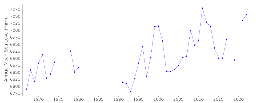
| Annual MSL (RLR) data | RLR 1115 |
| Annual MSL (RLR) plot | |
| MSL method | Hourly means |
| PSMSL code | 1115 |
| Other relevant codes | NTF port no. 62370, UHSLC 167 |
| Additional information | |
| Other relevant information | Float/stilling well analogue gauge operated at Main Jetty 1964-1977. Float/stilling/well analogue gauge operated in present location in the boat harbour 1977-1989. Geo. measurement: Precise ephemeris, doppler fix, Brown Range GC18A,1982 PSMSL also hold data from another gauge in Carnarvon (PSMSL Code 680/480 1966-1976, 1978-1982, 1984). |
| Nearest Met. station | Carnarvon Airport |
| Last updated | 16 October 2002 |
Real time data plot
Carnarvon, Australia