GLOSS Station Handbook – Port Hedland
The GLOSS Station Handbook is currently being re-designed and upgraded.
Until a new version is available, the tide gauge station list below from the last version of the Handbook provides links to further details about each tide gauge in the GLOSS Core Network. Click column headings to sort the station list table. Click the GLOSS number buttons to view the station information.
Station information
| General | |
|---|---|
| Gloss number | 51 |
| Station name | Port Hedland |
| Country | Australia |
| Time zone | 120E, GMT + 8hrs |
| Latitude (+ve N) | -20.31666 |
| Longitude (+ve E) | 118.56666 |
| Ocean | Indian |
| Observation periods | 1960; 1966- |
| Responsible country | Australia |
| Authority responsible for tide gauge | Port Hedland Port Auth., PO Box 2, Port Hedland, WA 6721. Dept. of Transport, Marine Division, PO Box 402, Fremantle WA 6160, Australia |
| GLOSS contact | Australia |
| Committed to GLOSS | Yes |
| Operational | Yes |
| Instrumentation | |
| Float | Yes |
| Pressure | No |
| Bubbler | No |
| Acoustic | No |
| Radar | No |
| Data | |
| Digital data | Yes |
| Additional parameters | None |
| Data acquisition rate | 5 minute samples |
| High frequency data at UHSLC | Data 169a Document 169a File format |
| Real-time data available | No |
| Additional parameters (real-time) | None |
| Benchmarks | |
| Tide gauge benchmark | DMH 101: A brass plaque set into concrete deck of No. 3 Berth beneath the salt gantry. It replaces A110 which was destroyed. |
| Benchmark relationships | Tide Gauge Zero (TGZ) = 9.761m below TGBM (1989 onwards) TGZ = 4.132m below Australian Height Datum (AHD) |
| Auxiliary benchmarks | A108: A PWD bronze plaque set in concrete decking of No. 1 Berth. A109: A PWD bronze plaque set in concrete decking of No. 1 Berth beneath the lighting tower at the south end of the berth. PH1: A PWD plaque set in concrete block in front of the PWD office, Anderson Street. |
| Data at PSMSL | |
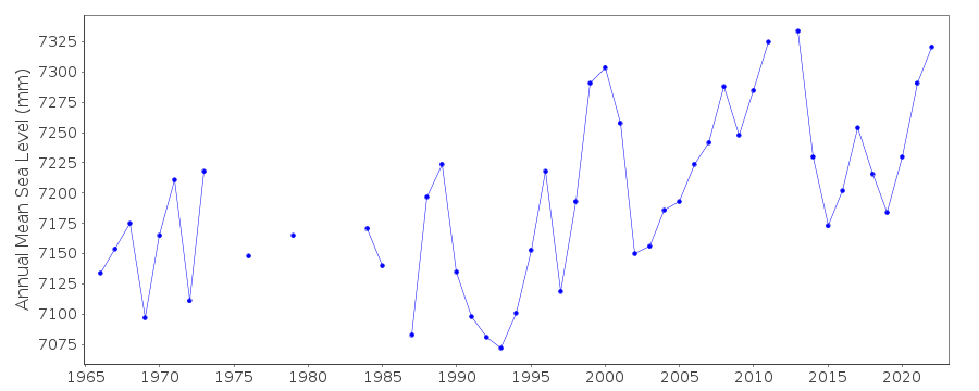
| Annual MSL (RLR) data | RLR 189 |
| Annual MSL (RLR) plot | |
| MSL method | Hourly means |
| PSMSL code | 189 |
| Other relevant codes | NTF port no. 62590, UHSLC 169 |
| Additional information | |
| Other relevant information | Float/stilling well gauge 1901-1912 Float/stilling well gauge 1912-1961 Float/stilling well gauge 1961-1969 on No.2 Wharf Float/stilling well gauge 1969- on No.3 Wharf Datum was raised by 0.579m on 01 Apr 1963, then lowered by 1.000m on 01 Jan 1975. |
| Nearest Met. station | Port Hedland Airport |
| Last updated | 16 October 2002 |
Real time data plot
Port Hedland, Australia