GLOSS Station Handbook – Pointe La Rue
The GLOSS Station Handbook is currently being re-designed and upgraded.
Until a new version is available, the tide gauge station list below from the last version of the Handbook provides links to further details about each tide gauge in the GLOSS Core Network. Click column headings to sort the station list table. Click the GLOSS number buttons to view the station information.
Station information
| General | |
|---|---|
| Gloss number | 339 |
| Station name | Pointe La Rue |
| Country | Seychelles |
| Time zone | GMT + 4hrs |
| Latitude (+ve N) | -4.67166 |
| Longitude (+ve E) | 55.52666 |
| Ocean | Indian |
| Observation periods | 1962-1964, 1975-1976, 1978-1979, 1992-..., Time span of data 1993-2004 (psmsl), |
| Responsible country | Seychelles |
| Authority responsible for tide gauge | Directorate of Civil Aviation, P.O. Box 181, Seychelles International Airport, Seychelles |
| Committed to GLOSS | No |
| Operational | Yes |
| Instrumentation | |
| Float | Yes |
| Pressure | No |
| Bubbler | No |
| Acoustic | No |
| Radar | No |
| Data | |
| Digital data | Yes |
| Additional parameters | The only oceanographic observations are tide, sea level monitoring and sea temperature measurement. Further Marine and oceanographic activities are carried out by other organizations. |
| Data acquisition rate | Tide Gauge samples every second and averages every one minute, and transmits the data every 15 min to University of Hawaii. |
| Fast delivery data at UHSLC | Data 121 File format |
| High frequency data at UHSLC | Document 121a |
| Real-time data available | Yes |
| Additional parameters (real-time) | None |
| Benchmarks | |
| Tide gauge benchmark | Tide Gauge location 04 40.3' S and 055 31.7' E. Tide Gauge GLOSS number 273, Toga I053, NODC II 30054502 replaced old tide gauge located at Port Victoria, it is a float/ well, Handar 436-A, Encoder 436-B. |
| Data at PSMSL | |
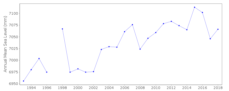
| Annual MSL (RLR) data | RLR 1846 |
| Annual MSL (RLR) plot | |
| PSMSL code | 1846 |
| Other relevant codes | UHLSC 121 |
| Additional information | |
| Other relevant information | Tide Gauge was installed on 11th of January 1993. Tide Gauge samples every second and averages every one minute, and transmits the data every 15 min to University of Hawaii through Meteosat 7 and GOES satellite. |
| Last updated | 8 June 2005 |
Real time data plot
Pointe La Rue, Seychelles