GLOSS Station Handbook – Takoradi
The GLOSS Station Handbook is currently being re-designed and upgraded.
Until a new version is available, the tide gauge station list below from the last version of the Handbook provides links to further details about each tide gauge in the GLOSS Core Network. Click column headings to sort the station list table. Click the GLOSS number buttons to view the station information.
Station information
| General | |
|---|---|
| Gloss number | 335 |
| Station name | Takoradi |
| Country | Ghana |
| Time zone | GMT ( hours 00-23) |
| Latitude (+ve N) | 4.88333 |
| Longitude (+ve E) | -1.75 |
| Observation periods | 4 January 2007 to 30 April 2010, Time span of data 1929- 2009 (psmsl) |
| Responsible country | Ghana |
| Authority responsible for tide gauge | Survey Department, P.O. Box 191, Cantonments, Accra, Ghana |
| Data | |
| Additional parameters | The gauge at Takoradi GLOSS station is based on bottom- pressure measurements. Temperature output is provided and absolute pressure is sampled at 2Hz and averaged. |
| Data acquisition rate | Every 15 min. |
| High frequency data at UHSLC | Document 231a |
| Additional parameters (real-time) | None |
| Benchmarks | |
| Tide gauge benchmark | TGBM GCS BM H4 Main Benchmark. Marker on tide gauge, close to radar mount |
| Benchmark relationships | Chart Datum= 3.086m below TGBM GCS BM H4 Chart Datum= 3.292m below HB TAK3 Chart Datum= 3.357m below SG1 Chart Datum= 3.415m below SG2 Chart Datum= 3.297m below SGN1 Chart Datum= 6.067m below TKTG Chart Datum= 4.179m below SGN9 Chart Datum= 24.943m below SGN3 Chart Datum= 25.042m below SGW346 Chart Datum= 28.288m below GPS 4C Chart Datum= 30.427m below SGWH1 Chart Datum= 30.642m below SGN4 Chart Datum= 34.451m below GPS1_Roof |
| Auxiliary benchmarks | HB TAK3 Benchmark roughly 10m to the right of the tide gauge SG1 Benchmark roughly 10m to the left of the tide gauge SG2 Near the TKTG GNSS station SGN1 Between tide gauge and harbour entrance, close to a large building TKTG Takoradi Tide Gauge GNSS station - 30m from tide gauge SGN9 At harbour entrance SGN3 On entrance of roundabout from the harbour SGW346 In centre of Roundabout GPS4C Auxiliary marker of TKRD, close to church SGWH1 Pillar in front of Survey Department of Ghana office SGN4 On left side of stairs of Survey Department of Ghana Office GPS1_Roof Marker in roof near TKRD GPS2_roof Marker in edge of roof of TKRD TKRD GNSS station on roof of Survey Department of Ghana Office |
| Data at PSMSL | |
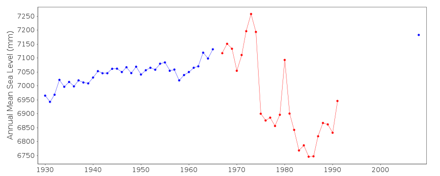
| Annual MSL (RLR) data | RLR 331 |
| Annual MSL (RLR) plot | |
| PSMSL code | 331 |
| Additional information | |
| Other relevant information | Chart Datum= 34.427 m below GPS2_Roof Chart Datum= 36.755m below TKRD Data from the start of series until May 2009 refer to local Chart Datum. After this, the station was relocated. The station started operating again in January 2010, but to a different, yet to be established datum. |
| Last updated | 4 November 2010 |
Real time data plot
Takoradi, Ghana