GLOSS Station Handbook – Virginia Keys
The GLOSS Station Handbook is currently being re-designed and upgraded.
Until a new version is available, the tide gauge station list below from the last version of the Handbook provides links to further details about each tide gauge in the GLOSS Core Network. Click column headings to sort the station list table. Click the GLOSS number buttons to view the station information.
Station information
| General | |
|---|---|
| Gloss number | 332 |
| Station name | Virginia Keys |
| Country | USA |
| Time zone | GMT- 4 hrs |
| Latitude (+ve N) | 25.73166 |
| Longitude (+ve E) | -80.16166 |
| Observation periods | Time span of data 1994-2010 |
| Authority responsible for tide gauge | N.O.A.A/ N.O.S., N/oes 33, Ssmc4, Room 6531, 1305 East-West Highway, Silver Spring, MD 20910, UNITED STATES |
| Data | |
| Additional parameters | Primary Water Level, Backup Water Level, Wind, Air Temperature, Water Temperature, Barometric Pressure |
| Fast delivery data at UHSLC | Data 755 File format |
| High frequency data at UHSLC | Document 755a |
| Additional parameters (real-time) | None |
| Data at PSMSL | |
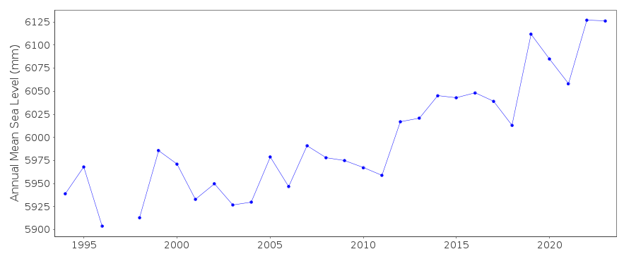
| Annual MSL (RLR) data | RLR 1858 |
| Annual MSL (RLR) plot | |
| PSMSL code | 1858 |
| Additional information | |
| Other relevant information | Tidal datum: January 1998- December 2009 Highest observed water level (10/24/2005) = 1.452 Mean higher high water MHHW = 0.666 Mean high water MHW = 0.650 North American Vertical Datum NAVD88 = 0.601 Mean tide level MTL = 0.342 Mean sea level MSL = 0.334 Mean low water MLW = 0.034 Mean lower low water MLLW = 0.000 Lowest observed water level (03/29/1994) = -0.400 |
| Last updated | 23 June 2011 |
Real time data plot
Virginia Keys, USA