GLOSS Station Handbook – Fort Pulaski, GA
The GLOSS Station Handbook is currently being re-designed and upgraded.
Until a new version is available, the tide gauge station list below from the last version of the Handbook provides links to further details about each tide gauge in the GLOSS Core Network. Click column headings to sort the station list table. Click the GLOSS number buttons to view the station information.
Station information
| General | |
|---|---|
| Gloss number | 289 |
| Station name | Fort Pulaski, GA |
| Country | U.S.A. |
| Time zone | 075W, GMT - 5hrs |
| Latitude (+ve N) | 32.03333 |
| Longitude (+ve E) | -80.9 |
| Ocean | Atlantic |
| Observation periods | 1935-, being upgraded 2007 |
| Responsible country | U.S.A. |
| Authority responsible for tide gauge | NOAA, National Ocean Service, 1305 East-West Highway, Silver Spring, MD 20910-3281, USA |
| GLOSS contact | USA |
| Committed to GLOSS | Yes |
| Operational | Yes |
| Location map | |
| Instrumentation | |
| Float | Yes |
| Pressure | No |
| Bubbler | Yes |
| Acoustic | Yes |
| Radar | No |
| Data | |
| Digital data | Yes |
| Additional parameters | Daily sea surface temperature and density |
| Data acquisition rate | 6 minute intervals |
| Fast delivery data at UHSLC | Data 752 File format |
| High frequency data at UHSLC | Data 752a Document 752a File format |
| Data held at national organisation | Yes |
| Real-time data available | Yes |
| Real-time data transmitted to GLOSS Fast Centre | |
| Additional parameters (real-time) | None |
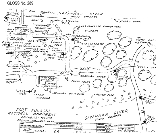
| Benchmarks | |
| Tide gauge benchmark | US C&GS benchmark survey disk stamped '5' set on a concrete post located south of the concrete parking lot for the Savannah Bar Pilot's Residence. |
| Benchmark relationships | TGBM = 12.75 feet above mean lower low water (1960-1978 epoch) TGBM = 8.95 feet above mean sea level (1960-1978 epoch) TGBM = 5.65 feet above mean high water (1960-1978 epoch) |
| Auxiliary benchmarks | 7' 0970 J 1977 11 1944 0870 K 1977 NO 1 1949 0870 L 1978 NO 2 1949 N323 1974 N323 1974 1993 inspection states: 'all benchmarks were recovered per NOS descriptions' |
| Data at PSMSL | |
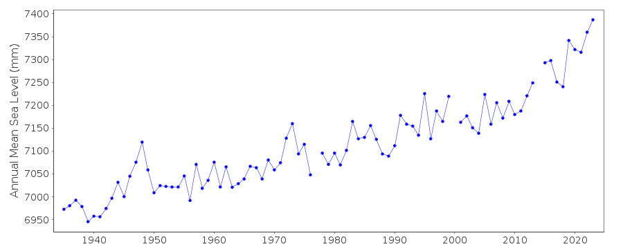
| Annual MSL (RLR) data | RLR 395 |
| Annual MSL (RLR) plot | |
| PSMSL code | 395 |
| Other relevant codes | UHSLC 752 |
| Additional information | |
| Last updated | 5 December 1993 |
Location map
Fort Pulaski, GA, U.S.A.
Real time data plot
Fort Pulaski, GA, U.S.A.