GLOSS Station Handbook – Hilo, Hawaiian Is.
The GLOSS Station Handbook is currently being re-designed and upgraded.
Until a new version is available, the tide gauge station list below from the last version of the Handbook provides links to further details about each tide gauge in the GLOSS Core Network. Click column headings to sort the station list table. Click the GLOSS number buttons to view the station information.
Station information
| General | |
|---|---|
| Gloss number | 287 |
| Station name | Hilo, Hawaiian Is. |
| Country | U.S.A. |
| Time zone | 150W, GMT - 10hrs |
| Latitude (+ve N) | 19.73333 |
| Longitude (+ve E) | -155.06666 |
| Ocean | Pacific |
| Observation periods | 1946- |
| Responsible country | U.S.A. |
| Authority responsible for tide gauge | NOAA, National Ocean Service, 1305 East-West Highway, Silver Spring, MD 20910-3281, USA |
| GLOSS contact | USA |
| Committed to GLOSS | Yes |
| Operational | Yes |
| Location map | |
| Instrumentation | |
| Float | Yes |
| Pressure | No |
| Bubbler | Yes |
| Acoustic | Yes |
| Radar | No |
| Data | |
| Digital data | Yes |
| Additional parameters | Surface temperature, density |
| Data acquisition rate | Digital gauge: 6 minute interval (after 1976) Analog gauge: hourly heights (before 1976) |
| Fast delivery data at UHSLC | Data 060 File format |
| High frequency data at BODC | Data 287 Document 60267 Document 83902 |
| High frequency data at UHSLC | Data 060a Document 060a File format |
| Data held at national organisation | Yes |
| Real-time data available | Yes |
| Real-time data transmitted to GLOSS Fast Centre | |
| Additional parameters (real-time) | None |
| Benchmarks | |
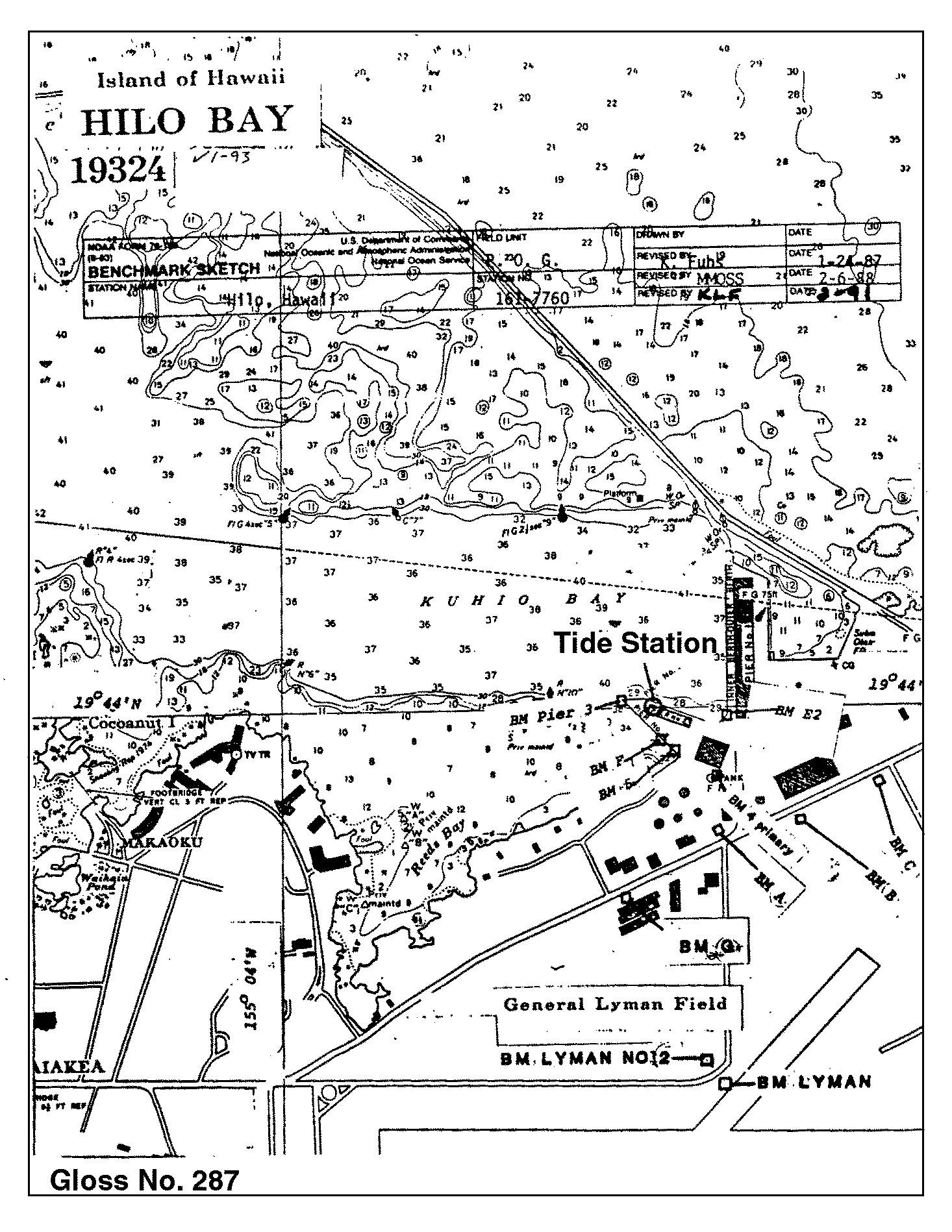
| Tide gauge benchmark | Benchmark 4(1951) is the primary benchmark (PBM) stamped 'NO 4 1951' set in top of east corner of northern-most concrete foundation which rests on solid rock for elevated water tank on Port of Hilo property. |
| Benchmark relationships | TGBM is 15.30ft above Tide Gauge Zero (Station Datum) NOAA Chart Datum (MLLW) is 3.69ft above Station Datum Mean Sea Level (1960-1978) is 4.86ft above Station Datum |
| Auxiliary benchmarks | 10 additional benchmarks are levelled to the TGBM and the Tide Station on a yearly basis (BM E2, BM Pier 3, BM F, BM 5, BM A, BM B, BM C, BM G, BM Lyman, BM Lyman NO 2) |
| Data at PSMSL | |
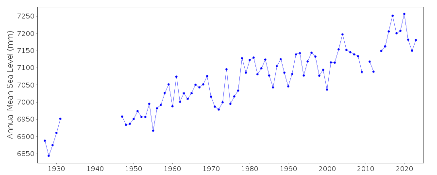
| Annual MSL (RLR) data | RLR 300 |
| Annual MSL (RLR) plot | |
| PSMSL code | 300 |
| Other relevant codes | UHSLC 060 |
| Additional information | |
| Last updated | 5 December 1993 |
Location map
Hilo, Hawaiian Is., U.S.A.
Real time data plot
Hilo, Hawaiian Is., U.S.A.