GLOSS Station Handbook – Fort Dauphin (Taolanaro)
The GLOSS Station Handbook is currently being re-designed and upgraded.
Until a new version is available, the tide gauge station list below from the last version of the Handbook provides links to further details about each tide gauge in the GLOSS Core Network. Click column headings to sort the station list table. Click the GLOSS number buttons to view the station information.
Station information
| General | |
|---|---|
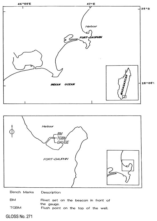
| Gloss number | 271 |
| Station name | Fort Dauphin (Taolanaro) |
| Country | Madagascar |
| Time zone | 045E, GMT + 3hrs |
| Latitude (+ve N) | -25.01666 |
| Longitude (+ve E) | 47.0 |
| Ocean | Indian |
| Observation periods | 1991- |
| Responsible country | Madagascar |
| Authority responsible for tide gauge | Department d'Oceanographie Physique et Chimique (C.N.R.O.), BP 68 (207) Nosy-Be, Madagascar Tel: 86 613 73 |
| GLOSS contact | Madagascar |
| Committed to GLOSS | Yes |
| Operational | Yes |
| Location map | |
| Instrumentation | |
| Float | Yes |
| Pressure | No |
| Bubbler | No |
| Acoustic | No |
| Radar | No |
| Data | |
| Digital data | Yes |
| Data acquisition rate | continuous recording, filtered to hourly data. |
| Real-time data available | No |
| Additional parameters (real-time) | None |
| Benchmarks | |
| Tide gauge benchmark | Hydro-benchmark situated on the top of the well |
| Benchmark relationships | Tide gauge zero (TGZ) = zero hydrographic TGZ = 2.78m below TGBM TGBM = 1.03m below benchmark BM: rivet set on the beacon in front of the tide gauge hut |
| Auxiliary benchmarks | Rivet set on the beacon in front of the gauge, 3.81m above zero hydrographic |
| Data at PSMSL | |
| MSL method | Doodson X0 filter |
| Additional information | |
| Other relevant information | The tide gauge has been adjusted by direct surveying with the hydrographic zero reference. The zero of tide state coincides with the hydrographic zero reference. |
| Last updated | 28 January 1998 |
Location map
Fort Dauphin (Taolanaro), Madagascar