GLOSS Station Handbook – Stornoway
The GLOSS Station Handbook is currently being re-designed and upgraded.
Until a new version is available, the tide gauge station list below from the last version of the Handbook provides links to further details about each tide gauge in the GLOSS Core Network. Click column headings to sort the station list table. Click the GLOSS number buttons to view the station information.
Station information
| General | |
|---|---|
| Gloss number | 238 |
| Station name | Stornoway |
| Country | U.K. |
| Time zone | 000E, GMT |
| Latitude (+ve N) | 58.2 |
| Longitude (+ve E) | -6.38333 |
| Ocean | Atlantic |
| Observation periods | 1928-1983 Stilling Well/Float 1985 - Bubbler gauge |
| Responsible country | U.K. |
| Authority responsible for tide gauge | National Oceanography Centre, Joseph Proudman Building, 6 Brownlow Street, Liverpool, L3 5DA, UK |
| GLOSS contact | UK |
| Committed to GLOSS | Yes |
| Operational | Yes |
| Location map | |
| Instrumentation | |
| Float | No |
| Pressure | No |
| Bubbler | Yes |
| Acoustic | No |
| Radar | No |
| Data | |
| Digital data | Yes |
| Additional parameters | Mid-tide datum |
| Data acquisition rate | Recording at 15 minute intervals, filtered to hourly heights. |
| Fast delivery data at UHSLC | Data 295 File format |
| High frequency data at BODC | Data 238 Document 45014 Document 83389 |
| High frequency data at UHSLC | Data 295a Document 295a File format |
| Data held at national organisation | Yes |
| Real-time data available | Yes |
| Additional parameters (real-time) | None |
| Benchmarks | |
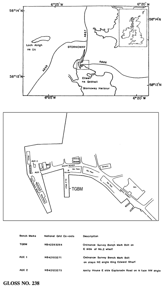
| Tide gauge benchmark | Ordnance Survey Benchmark bolt E side of No. 2 Wharf (Bank Street Wharf) Ordnance Survey grid reference NB 4228 3264 |
| Benchmark relationships | Tide gauge zero (TGZ) = Admiralty Chart Datum (ACD) TGZ = 2.71m below Local Ordnance Datum TGZ = 6.368m below TGBM (from 1988 onwards) |
| Auxiliary benchmarks | AUX 1: Ordnance Survey Benchmark bolt in steps NE angle of King Edward Wharf. Ordnance Survey grid reference NB 4215 3271. AUX 2: Amity House, E side of Esplanade Road, N face, NW angle. Ordnance Survey grid reference NB 4212 3275. AUX 3: Bank S side of Worth Beach, NW angle, N face. Ordnance Survey grid reference NB 4223 3280. |
| Data at PSMSL | |
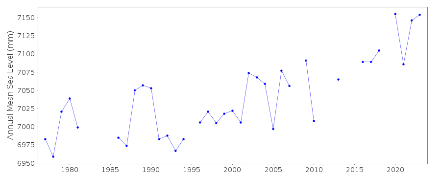
| Annual MSL (RLR) data | RLR 314 |
| Annual MSL (RLR) plot | |
| MSL method | Doodson X0 filter |
| PSMSL code | 314 |
| Other relevant codes | UHSLC 295 |
| Additional information | |
| Nearest Met. station | Stornoway airport |
| Last updated | 16 February 2005 |
Location map
Stornoway, U.K.
Real time data plot
Stornoway, U.K.