GLOSS Station Handbook – St John's, Newfoundland
The GLOSS Station Handbook is currently being re-designed and upgraded.
Until a new version is available, the tide gauge station list below from the last version of the Handbook provides links to further details about each tide gauge in the GLOSS Core Network. Click column headings to sort the station list table. Click the GLOSS number buttons to view the station information.
Station information
| General | |
|---|---|
| Gloss number | 223 |
| Station name | St John's, Newfoundland |
| Country | Canada |
| Time zone | 052.5W, GMT - 3.5hrs |
| Latitude (+ve N) | 47.56666 |
| Longitude (+ve E) | -52.71666 |
| Ocean | Atlantic |
| Observation periods | 1925, 1935- |
| Responsible country | Canada |
| Authority responsible for tide gauge | Dept. of Fisheries and Oceans, CHS Maritimes, Bedford Institute of Oceanography, P.O. Box 1006, Dartmouth, NS, B2Y 4A2, Canada |
| GLOSS contact | Canada |
| Committed to GLOSS | Yes |
| Operational | Yes |
| Location map | |
| Instrumentation | |
| Float | Yes |
| Pressure | No |
| Bubbler | Yes |
| Acoustic | No |
| Radar | No |
| Data | |
| Digital data | Yes |
| Data acquisition rate | Continuous graph and 15 minute intervals, sampled hourly. |
| Fast delivery data at UHSLC | Data 276 File format |
| High frequency data at BODC | Data 223 Document 34131 |
| High frequency data at UHSLC | Data 276a Data 276b Document 276a Document 276b File format |
| Real-time data available | Yes |
| Additional parameters (real-time) | None |
| Benchmarks | |
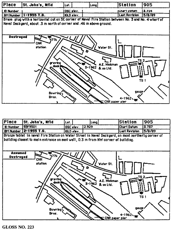
| Tide gauge benchmark | 90F9000 A CHS tablet set vertically in the base of a concrete colonnade at the NE corner of the building of the Harvey Oil office. The building has a brick north face. The tablet is set into the top of the base 0.3m above the asphalt drive. |
| Benchmark relationships | 1957 BM75K elevation 7.276m above Chart Datum (also see below) 1958-1959 BM HS elevation 7.276m above Chart Datum 1960-1979 BM77K elevation 3.602m above Chart Datum 1980-1987 BM77K elevation 3.602m above Chart Datum |
| Auxiliary benchmarks | 77K A GSC tablet set horizontally in the Canadian National Railway Station west wall, 1m north of the main entrance and 0.9m below a window. 87F9000 A CHS tablet set horizontally in the NE corner pillar of the auxiliary electrical building of the MOT complex. Tablet 0.58m above concrete base & 0.18m west of the corner of the bldg. Elevation is 3.562m above Chart Datum. |
| Data at PSMSL | |
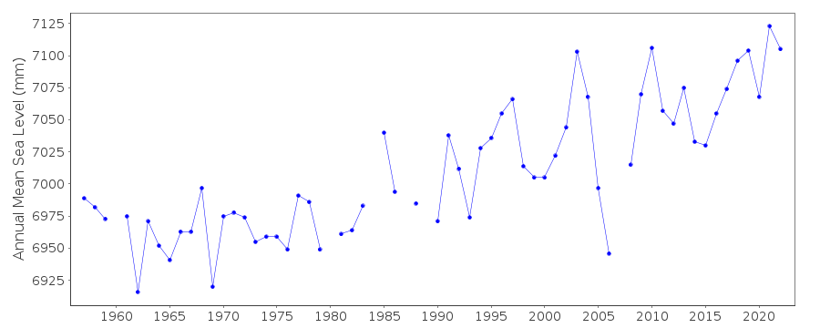
| Annual MSL (RLR) data | RLR 393 |
| Annual MSL (RLR) plot | |
| MSL method | Mean of hourly heights |
| PSMSL code | 393 |
| Other relevant codes | UHSLC 276 |
| Additional information | |
| Other relevant information | 1925-1937 Admiralty BM elevation 30.48m (Admiralty assumed datum) ** 1955-1956 BM76K elevation 7.154m above Chart Datum ** review pending Auxiliary Benchmarks continued: 87F9001 A CHS tablet set vertically in a concrete guard post located on the west side of the 3rd loading door on the north side of the main depot bldg.Data available at http://www.waterlevels.gc.ca, http://www.meds-sdmm.dfo-mpo.gc.ca/meds/Databases/TWL/TWL_inventory_e.htm and http://www.meds-sdmm.dfo-mpo.gc.ca/meds/prog_nat/benchmark/public/default_e.as |
| Nearest Met. station | St. John's Weather Service |
| Last updated | 10 November 1997 |
Location map
St John's, Newfoundland, Canada
Real time data plot
St John's, Newfoundland, Canada