GLOSS Station Handbook – Halifax
The GLOSS Station Handbook is currently being re-designed and upgraded.
Until a new version is available, the tide gauge station list below from the last version of the Handbook provides links to further details about each tide gauge in the GLOSS Core Network. Click column headings to sort the station list table. Click the GLOSS number buttons to view the station information.
Station information
| General | |
|---|---|
| Gloss number | 222 |
| Station name | Halifax |
| Country | Canada |
| Time zone | 060W, GMT - 4hrs |
| Latitude (+ve N) | 44.66666 |
| Longitude (+ve E) | -63.58333 |
| Ocean | Atlantic |
| Observation periods | 1895-1907, 1919- |
| Responsible country | Canada |
| Authority responsible for tide gauge | Dept. of Fisheries and Oceans, CHS Maritimes, Bedford Institute of Oceanography, P.O. Box 1006, Dartmouth, N.S., B2Y 4A2, Canada |
| GLOSS contact | Canada |
| Committed to GLOSS | Yes |
| Operational | Yes |
| Location map | |
| Instrumentation | |
| Float | Yes |
| Pressure | No |
| Bubbler | No |
| Acoustic | No |
| Radar | No |
| Data | |
| Digital data | Yes |
| Data acquisition rate | Continuous graph (sampled hourly) 15 minutes (electronic) |
| Fast delivery data at UHSLC | Data 275 File format |
| High frequency data at BODC | Data 222 Document 75050 |
| High frequency data at UHSLC | Data 275a Document 275a File format |
| Real-time data available | Yes |
| Additional parameters (real-time) | None |
| Benchmarks | |
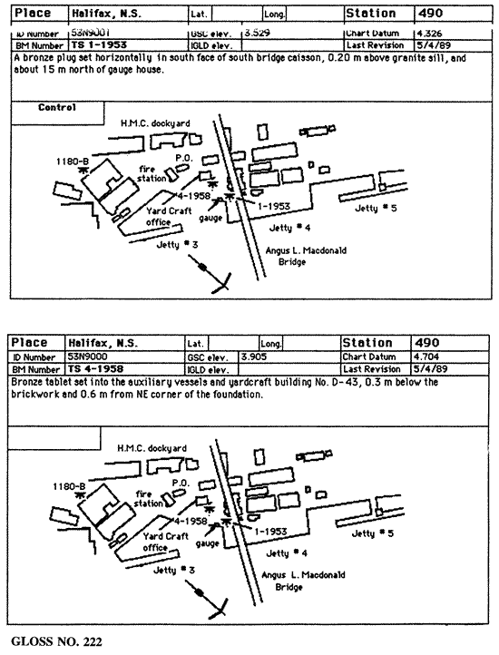
| Tide gauge benchmark | WSC1-1981 A Water Survey of Canada tablet set horizontally in the NE face of the SE corner of bldg. no. D-57, tablet 0.76m N of SE corner 0.15m below brickwork. Elevation 5.094m above Chart Datum (LNT). |
| Benchmark relationships | 1895-1907 Admiralty Datum of 25.58m (Admiralty assumed datum) *see below 1919-1939 Admiralty Datum of 25.58m (Admiralty assumed datum) *see below 1940-1955 Admiralty Datum of 25.58m (Admiralty assumed datum) *see below 1956- to date Canadian Hygrographic |
| Auxiliary benchmarks | WSC2-1981: A Water Survey of Canada tablet set horizontally in the NE face of the NW corner of bldg. no. D-34, tablet 2.84m from N corner of bldg. and 0.30m above concrete walkway. Elevation 4.766m above LNT. 88N9000: A CHS tablet set horizontally in the SE corner of the new naval fire station foundation, 0.24m west of the SE corner of the bldg., 0.14m below brickwork. Elevation 8.208m above Chart Datum (LNT). 96N9000: A CHS set horizontally in the south face of the SW bridge (Angus L. Macdonald) caisson, 0.10m above granite sill, 0.20m east of the SW corner of the caisson, 0.80m above paved ground level surface and 15.0m NNW of gauge house. Elevation 4.278m above Chart Datum. |
| Data at PSMSL | |
| Annual MSL (RLR) data | RLR 96 |
| Annual MSL (RLR) plot | |
| MSL method | mean of hourly heights |
| PSMSL code | 96 |
| Other relevant codes | UHSLC 275 |
| Additional information | |
| Other relevant information | Data available at http://www.waterlevels.gc.ca, http://www.meds-sdmm.dfo-mpo.gc.ca/meds/Databases/TWL/TWL_inventory_e.htm and http://www.meds-sdmm.dfo-mpo.gc.ca/meds/prog_nat/benchmark/public/default_e.as |
| Nearest Met. station | Bedford, Nova Scotia |
| Last updated | 10 November 1997 |
Location map
Halifax, Canada
Real time data plot
Halifax, Canada
