GLOSS Station Handbook – Duck, N.C.
The GLOSS Station Handbook is currently being re-designed and upgraded.
Until a new version is available, the tide gauge station list below from the last version of the Handbook provides links to further details about each tide gauge in the GLOSS Core Network. Click column headings to sort the station list table. Click the GLOSS number buttons to view the station information.
Station information
| General | |
|---|---|
| Gloss number | 219 |
| Station name | Duck, N.C. |
| Country | U.S.A. |
| Time zone | 075W, GMT - 5hrs |
| Latitude (+ve N) | 35.18333 |
| Longitude (+ve E) | -75.75 |
| Ocean | Atlantic |
| Observation periods | 1979-, being upgraded 2007 |
| Responsible country | U.S.A. |
| Authority responsible for tide gauge | NOAA, National Ocean Service, 1305 East-West Highway, Silver Spring, MD 20910-3281, USA |
| GLOSS contact | USA |
| Committed to GLOSS | Yes |
| Operational | Yes |
| Instrumentation | |
| Float | Yes |
| Pressure | No |
| Bubbler | Yes |
| Acoustic | Yes |
| Radar | No |
| Data | |
| Digital data | Yes |
| Additional parameters | Daily sea surface temperature and density |
| Data acquisition rate | 6 minute intervals |
| Fast delivery data at UHSLC | Data 260 File format |
| High frequency data at BODC | Data 219 Document 58759 |
| High frequency data at UHSLC | Data 260a Document 260a File format |
| Data held at national organisation | Yes |
| Real-time data available | Yes |
| Real-time data transmitted to GLOSS Fast Centre | |
| Additional parameters (real-time) | None |
| Benchmarks | |
| Tide gauge benchmark | NOS tide gauge benchmark survey disk stamped '865 1370 B 1977' set atop a galvanised steel deep rod located in the US Army Corps of Engineers? Facility Compound, Duck, NC. |
| Benchmark relationships | TGBM = 14.80 feet above mean lower low water (1960-1978 epoch) TGBM = 12.99 feet above mean sea level (1960-1978 epoch) TGBM = 11.37 feet above mean high water (1960-1978 epoch) |
| Auxiliary benchmarks | 865 1370 A 1977 1370 H 1980 865 1370 C 1977 1370 J 1980 865 1370 D 1977 1370 K 1980 1370 E 1979 #64 1370 F 1979 1370 G 1980 |
| Data at PSMSL | |
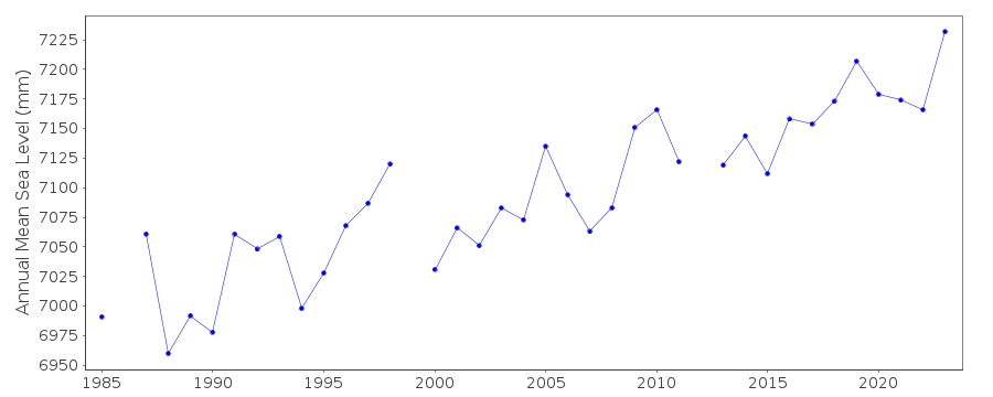
| Annual MSL (RLR) data | RLR 1636 |
| Annual MSL (RLR) plot | |
| PSMSL code | 1636 |
| Other relevant codes | UHSLC 260 |
| Additional information | |
| Other relevant information | GPS nearby |
| Last updated | 5 December 1993 |
Real time data plot
Duck, N.C., U.S.A.