GLOSS Station Handbook – Galveston (Pier 21), TX
The GLOSS Station Handbook is currently being re-designed and upgraded.
Until a new version is available, the tide gauge station list below from the last version of the Handbook provides links to further details about each tide gauge in the GLOSS Core Network. Click column headings to sort the station list table. Click the GLOSS number buttons to view the station information.
Station information
| General | |
|---|---|
| Gloss number | 217 |
| Station name | Galveston (Pier 21), TX |
| Country | U.S.A. |
| Time zone | 090W, GMT - 6hrs |
| Latitude (+ve N) | 29.31666 |
| Longitude (+ve E) | -94.8 |
| Ocean | Atlantic |
| Observation periods | 1908-, being upgraded 2007 |
| Responsible country | U.S.A. |
| Authority responsible for tide gauge | NOAA, National Ocean Service, 1305 East-West Highway, Silver Spring, MD 20910-3281, USA |
| GLOSS contact | USA |
| Committed to GLOSS | Yes |
| Operational | Yes |
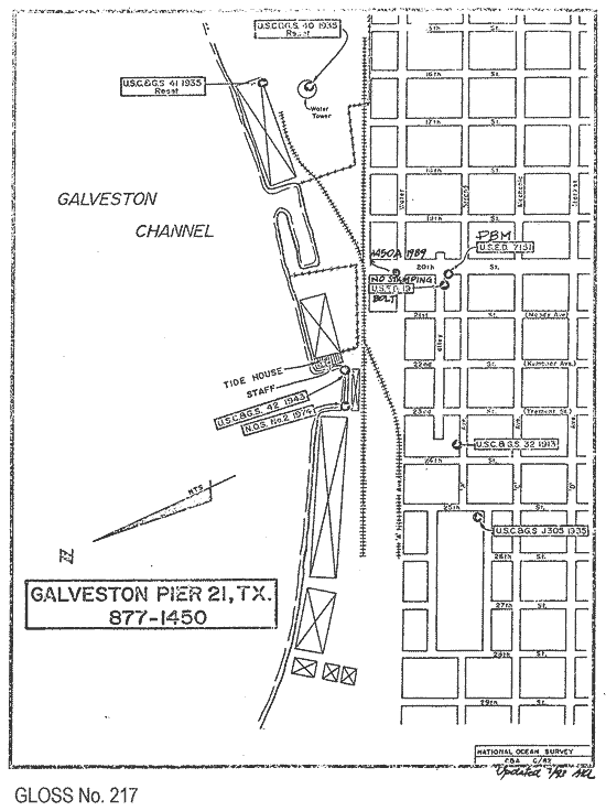
| Location map | |
| Instrumentation | |
| Float | Yes |
| Pressure | Yes |
| Bubbler | Yes |
| Acoustic | Yes |
| Radar | No |
| Data | |
| Digital data | Yes |
| Additional parameters | Surface temperature and density |
| Data acquisition rate | 6 minute intervals |
| Fast delivery data at UHSLC | Data 775 File format |
| High frequency data at UHSLC | Data 775a Document 775a File format |
| Data held at national organisation | Yes |
| Real-time data available | Yes |
| Real-time data transmitted to GLOSS Fast Centre | |
| Additional parameters (real-time) | None |
| Benchmarks | |
| Tide gauge benchmark | US Army Corps of Engineers survey disk stamped '7.151' set in the sidewalk near the northeast corner of the Hendley Building on 20th Street, Galveston, TX. |
| Benchmark relationships | TGBM is 10.183 feet above tide staff zero TGBM = 5.63 feet above mean lower low water (1960-1978 epoch) TGBM = 4.81 feet above mean sea level (1960-1978 epoch) TGBM = 4.31 feet above mean high water (1960-1978 epoch) |
| Auxiliary benchmarks | USC & GS 32 1913 No stamping 1 = 13.362ft USC & GS J305 1935 USED 19 bolt USC & GS 40 1935 reset 1450A 1989 = 11.058ft USC & GS 41 1935 reset Aquatrak Levelling Point = 20.147ft USC & GS 42 1943 = 9.981ft NOS NO 2 1974 = 9.979ft Heights are in feet above staff zero |
| Data at PSMSL | |
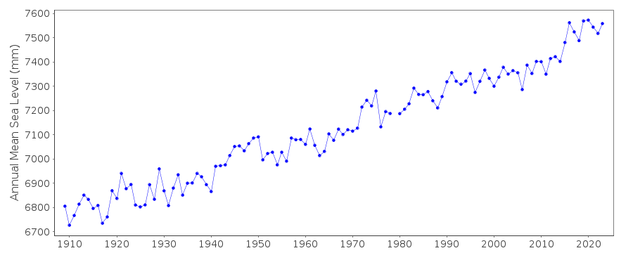
| Annual MSL (RLR) data | RLR 828 RLR 161 |
| Annual MSL (RLR) plot | |
| PSMSL code | 161 |
| Other relevant codes | UHSLC 775 |
| Additional information | |
| Other relevant information | Nearby station located at Galveston Pleasure Pier (outside on the Gulf of Mexico) has shorter and less continuous record length than Galveston Pier 21 (inside) station described above (PSMSL Code 940/007; PSMSL hold data 1957-1973, 1978-1990). |
| Last updated | 5 December 1993 |
Location map
Galveston (Pier 21), TX, U.S.A.
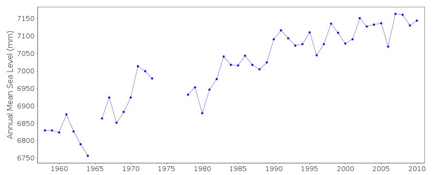
Real time data plot
Galveston (Pier 21), TX, U.S.A.
Real time data plot
Galveston (Pier 21), TX, U.S.A.