GLOSS Station Handbook – Ponta da Madeira
The GLOSS Station Handbook is currently being re-designed and upgraded.
Until a new version is available, the tide gauge station list below from the last version of the Handbook provides links to further details about each tide gauge in the GLOSS Core Network. Click column headings to sort the station list table. Click the GLOSS number buttons to view the station information.
Station information
| General | |
|---|---|
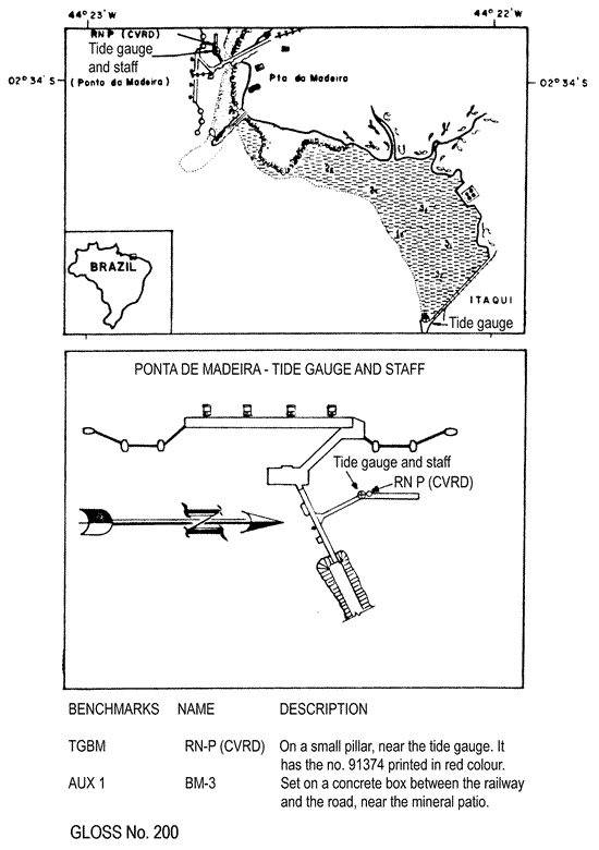
| Gloss number | 200 |
| Station name | Ponta da Madeira |
| Country | Brazil |
| Time zone | 045W, GMT - 3hrs |
| Latitude (+ve N) | -2.56666 |
| Longitude (+ve E) | -44.36666 |
| Ocean | Atlantic |
| Observation periods | 1985- |
| Responsible country | Brazil |
| Authority responsible for tide gauge | Companhia Vale do Rio Doce Superintendencia dos Portos-P da Madeira, BNR 123, km 7, s/n, 65085 Sao Luis, MA, Brazil |
| GLOSS contact | Brazil |
| Committed to GLOSS | Yes |
| Operational | Yes |
| Location map | |
| Instrumentation | |
| Float | Yes |
| Pressure | No |
| Bubbler | No |
| Acoustic | No |
| Radar | No |
| Data | |
| Data acquisition rate | Hourly |
| Real-time data available | No |
| Additional parameters (real-time) | None |
| Benchmarks | |
| Tide gauge benchmark | RN-P(CVRD) - bronze mark at a small pilar, near the tide gauge on the right. It has the no. 91374 printed in red colour. |
| Benchmark relationships | Tide Gauge Zero (TGZ) = chart datum TGZ = 913.7cm below TGBM TGZ = 343.0cm below mean sea level |
| Auxiliary benchmarks | BM-3 (CVRD) - set on a concrete box between the railway and the road, near the mineral patio. |
| Data at PSMSL | |
| Annual MSL (RLR) data | Yes (Monthly metric data only available) |
| MSL method | Godin filter |
| PSMSL code | 1736 |
| Additional information | |
| Nearest Met. station | 00101 - Ponta da Madeira |
| Last updated | 28 November 1993 |
Location map
Ponta da Madeira, Brazil