GLOSS Station Handbook – Ushuaia
The GLOSS Station Handbook is currently being re-designed and upgraded.
Until a new version is available, the tide gauge station list below from the last version of the Handbook provides links to further details about each tide gauge in the GLOSS Core Network. Click column headings to sort the station list table. Click the GLOSS number buttons to view the station information.
Station information
| General | |
|---|---|
| Gloss number | 181 |
| Station name | Ushuaia |
| Country | Argentina |
| Time zone | 045W, GMT - 3hrs |
| Latitude (+ve N) | -54.81666 |
| Longitude (+ve E) | -68.3 |
| Ocean | Atlantic |
| Observation periods | Float/stilling well 1970- Acoustic 1992- |
| Responsible country | Argentina |
| Authority responsible for tide gauge | Servicio de Hidrografia Naval, Dto. Oceanografia, Avda. Montes de Oca 2124, C.P. 1271 Buenos Aires, Republica Argentina. http://www.hidro.gov.ar/ |
| GLOSS contact | Argentina |
| Committed to GLOSS | Yes |
| Operational | Yes |
| Location map | |
| Instrumentation | |
| Float | Yes |
| Pressure | No |
| Bubbler | Yes |
| Acoustic | Yes |
| Radar | No |
| Data | |
| Digital data | Yes |
| Additional parameters | wind speed/direction/gust, air & water temp., air pressure |
| Data acquisition rate | Float/stilling well: hourly recording Acoustic: six minute recording |
| Fast delivery data at UHSLC | Data 600 File format |
| High frequency data at BODC | Data 181 Document 77990 |
| High frequency data at UHSLC | Data 600a Document 600a File format |
| Real-time data available | Yes |
| Real-time data transmitted to GLOSS Fast Centre | |
| Additional parameters (real-time) | None |
| Benchmarks | |
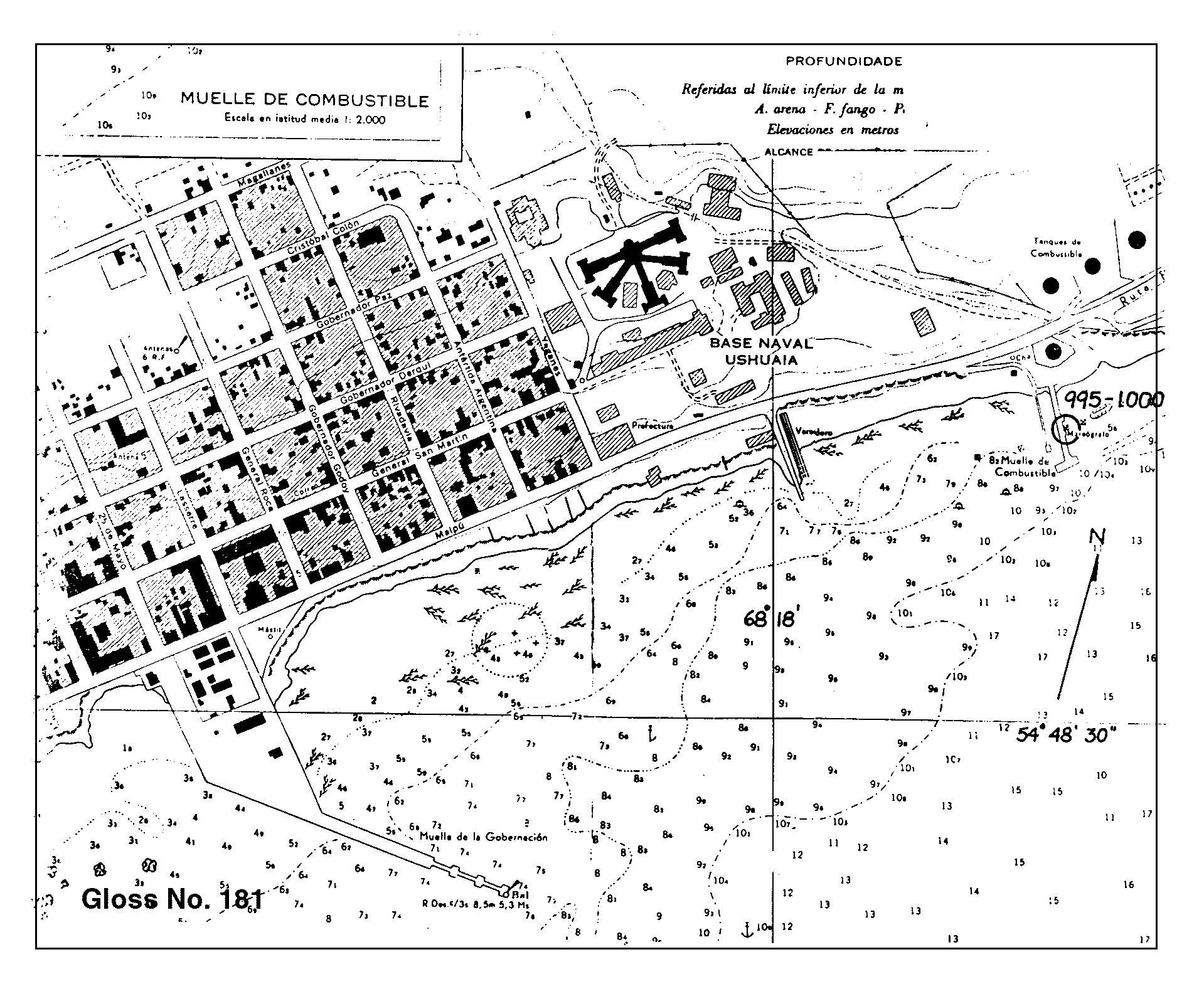
| Tide gauge benchmark | Benchmark bolt inside tide gauge hut adjacent to stilling well. Acoustic gauge is referred to the same benchmarks as the float gauge. Aquatrack levelling point is 10.000m above an arbitrary 'zero'. |
| Benchmark relationships | Tide gauge zero (TGZ) = local chart datum TGZ = 5.52m below TGBM (from 1951 onwards) NOAA Gage 0 is designated as 2.0000m below chart zero. Chart zero refers to MLLW, indicated on the Plano de Reduccion de la Carta Argentina. |
| Auxiliary benchmarks | AUX 1: Punto fijo ubicado frente la Base Naval Ushuaia, en las adyacencias de la Comandancia Other benchmarks include: 1000 A 1991, 1000 B 1991, Unstamped 1, Unstamped 2, II, MOJON X1 1978. |
| Data at PSMSL | |
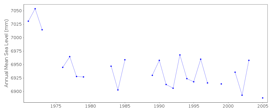
| Annual MSL (RLR) data | RLR 874 RLR 1271 |
| Annual MSL (RLR) plot | |
| MSL method | mean monthly hourly heights |
| PSMSL code | 1271 |
| Other relevant codes | UHSLC 600 |
| Additional information | |
| Other relevant information | Gauge was moved 900m in May 1970. PSMSL hold data collected prior to move (PSMSL Code 860/001, 1957-1969). |
| Last updated | 4 December 1993 |
Location map
Ushuaia, Argentina
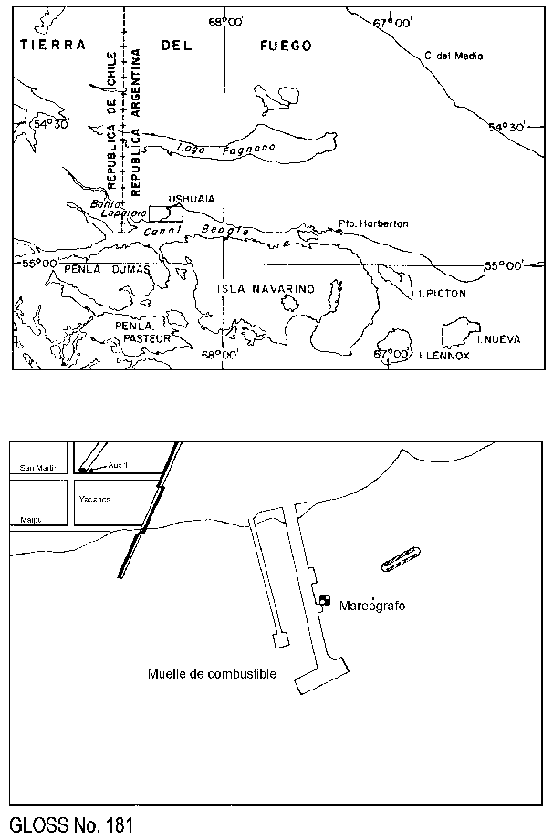
Location map
Ushuaia, Argentina
Real time data plot
Ushuaia, Argentina
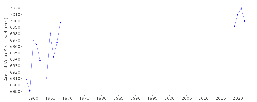
Real time data plot
Ushuaia, Argentina