GLOSS Station Handbook – Port Louis Harbour
The GLOSS Station Handbook is currently being re-designed and upgraded.
Until a new version is available, the tide gauge station list below from the last version of the Handbook provides links to further details about each tide gauge in the GLOSS Core Network. Click column headings to sort the station list table. Click the GLOSS number buttons to view the station information.
Station information
| General | |
|---|---|
| Gloss number | 18 |
| Station name | Port Louis Harbour |
| Country | Mauritius |
| Time zone | 060E, GMT + 4hrs |
| Latitude (+ve N) | -20.15 |
| Longitude (+ve E) | 57.5 |
| Ocean | Indian |
| Observation periods | August 1986- |
| Responsible country | Mauritius |
| Authority responsible for tide gauge | Meteorological Service, St Paul Road, Vacoas, Mauritius |
| GLOSS contact | Mauritius |
| Committed to GLOSS | Yes |
| Operational | Yes |
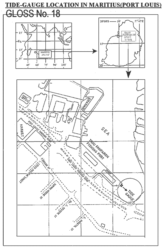
| Location map | |
| Instrumentation | |
| Float | Yes |
| Pressure | No |
| Bubbler | No |
| Acoustic | No |
| Radar | No |
| Data | |
| Digital data | Yes |
| Additional parameters | Mean Sea Level Pressure |
| Data acquisition rate | Continuous analogue record, but hourly values computed. Handar encoder 4 minute interval |
| Fast delivery data at UHSLC | Data 103 File format |
| High frequency data at BODC | Data 018a Data 018b Data 018c Document 57532 Document 57546 Document 57563 |
| Real-time data available | Yes |
| Real-time data transmitted to GLOSS Fast Centre | |
| Additional parameters (real-time) | None |
| Benchmarks | |
| Tide gauge benchmark | 1. 3m mark on tide staff 2. One brass bolt at edge of wharf of tide gauge 3. A bolt on the gauge |
| Benchmark relationships | 3m mark tied to the National Primary Levelling Network and Fundamental benchmark TTP30. The 3m mark is 1.6788m above Admiralty Chart Datum. The bolt on the gauge is 3.0488m above Admiralty Chart Datum. (February 1987 onwards) |
| Auxiliary benchmarks | One bolt flush with wall located about 7.5m west of station. |
| Data at PSMSL | |
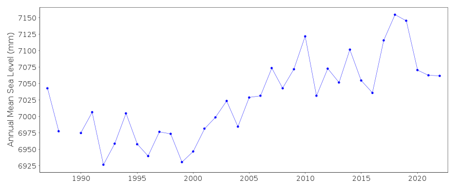
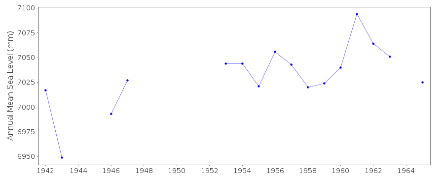
| Annual MSL (RLR) data | RLR 477 RLR 1673 |
| Annual MSL (RLR) plot | |
| MSL method | average of daily values |
| PSMSL code | 1673 |
| Other relevant codes | UHSLC 103 |
| Additional information | |
| Other relevant information | Munro tide gauge in a stone building, corner of Quay D, dismantled in early 1970s. Zero of recorder corresponds to a marked level situated seven feet below the level of the Quay. This datum point denotes the level of the mean low water at spring tides and was selected in 1929 after taking the average of the low water spring tide levels over a 48 month period. Local levellings are undertaken at intervals of 6 months. |
| Nearest Met. station | Meteorological station, Vacoas |
| Last updated | 20 December 1997 |
Location map
Port Louis Harbour, Mauritius
Real time data plot
Port Louis Harbour, Mauritius
Real time data plot
Port Louis Harbour, Mauritius