GLOSS Station Handbook – Prince Rupert
The GLOSS Station Handbook is currently being re-designed and upgraded.
Until a new version is available, the tide gauge station list below from the last version of the Handbook provides links to further details about each tide gauge in the GLOSS Core Network. Click column headings to sort the station list table. Click the GLOSS number buttons to view the station information.
Station information
| General | |
|---|---|
| Gloss number | 155 |
| Station name | Prince Rupert |
| Country | Canada |
| Time zone | 120W, GMT - 8hrs |
| Latitude (+ve N) | 54.31666 |
| Longitude (+ve E) | -130.33333 |
| Ocean | Pacific |
| Observation periods | 1906- |
| Responsible country | Canada |
| Authority responsible for tide gauge | Mr. G.H. Eaton, Canadian Hydrographic Service, Institute of Ocean Sciences, P.O. Box 6000, Sidney, British Columbia, V8L 4B2, |
| GLOSS contact | Canada |
| Committed to GLOSS | Yes |
| Operational | Yes |
| Location map | |
| Instrumentation | |
| Float | Yes |
| Pressure | No |
| Bubbler | No |
| Acoustic | No |
| Radar | No |
| Data | |
| Digital data | Yes |
| Data acquisition rate | Instantaneous values are measured every 15 minutes and stored in a data logger (TATS gauge). |
| Fast delivery data at UHSLC | Data 540 File format |
| High frequency data at BODC | Data 155 Document 75078 |
| High frequency data at UHSLC | Data 540a Data 540b Document 540a Document 540b File format |
| Real-time data available | Yes |
| Additional parameters (real-time) | None |
| Benchmarks | |
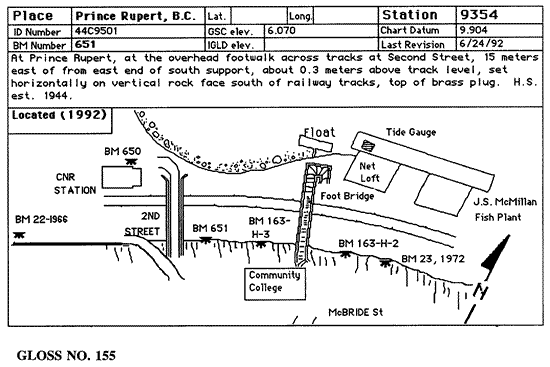
| Tide gauge benchmark | Controlling benchmark: BM 651, 1944 |
| Benchmark relationships | BM 651, 1944 is 9.904m above chart datum. BM 651, 1944 is 6.070m above geodetic datum. |
| Auxiliary benchmarks | BM 650 elevation 10.756m above chart datum 22,1966 elevation 10.876m above chart datum 23,1972 elevation 10.323m above chart datum 163-H-3 elevation 10.737m above chart datum 163-H-2 elevation 10.784m above chart datum |
| Data at PSMSL | |
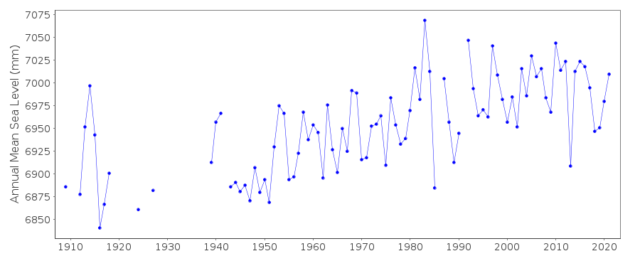
| Annual MSL (RLR) data | RLR 167 |
| Annual MSL (RLR) plot | |
| MSL method | average of hourly heights |
| PSMSL code | 167 |
| Other relevant codes | UHSLC 540 |
| Additional information | |
| Other relevant information | Water level information is downloaded by the CHS twice a week. Gauge is tied to controlling benchmarks on an annual basis. Vertical control is also maintained by sight gauge readings and by the use of reference level switches. Data available at http://www.waterlevels.gc.ca, http://www.meds-sdmm.dfo-mpo.gc.ca/meds/Databases/TWL/TWL_inventory_e.htm and http://www.meds-sdmm.dfo-mpo.gc.ca/meds/prog_nat/benchmark/public/default_e.as |
| Nearest Met. station | Prince Rupert |
| Last updated | 10 November 1997 |
Location map
Prince Rupert, Canada
Real time data plot
Prince Rupert, Canada