GLOSS Station Handbook – Rarotonga
The GLOSS Station Handbook is currently being re-designed and upgraded.
Until a new version is available, the tide gauge station list below from the last version of the Handbook provides links to further details about each tide gauge in the GLOSS Core Network. Click column headings to sort the station list table. Click the GLOSS number buttons to view the station information.
Station information
| General | |
|---|---|
| Gloss number | 139 |
| Station name | Rarotonga |
| Country | Cook Islands |
| Time zone | 150W, GMT - 10hrs |
| Latitude (+ve N) | -21.2 |
| Longitude (+ve E) | -159.76666 |
| Ocean | Pacific |
| Observation periods | Float gauge 1977-; Acoustic gauge 1993- |
| Responsible country | Australia |
| Authority responsible for tide gauge | National Tidal Centre, Australia (see GLOSS Contact Points). |
| GLOSS contact | Australia |
| Committed to GLOSS | Yes |
| Operational | Yes |
| Location map | |
| Instrumentation | |
| Float | Yes |
| Pressure | No |
| Bubbler | No |
| Acoustic | Yes |
| Radar | No |
| Data | |
| Digital data | Yes |
| Additional parameters | Barometric pressure, water and air temperature, wind speed and direction. |
| Data acquisition rate | 6 minute intervals |
| Fast delivery data at UHSLC | Data 023 File format |
| High frequency data at BODC | Data 139 Document 77230 Document 57345 |
| High frequency data at UHSLC | Data 023a Data 023b Document 023a Document 023b File format |
| Real-time data available | Yes |
| Real-time data transmitted to GLOSS Fast Centre | |
| Additional parameters (real-time) | None |
| Benchmarks | |
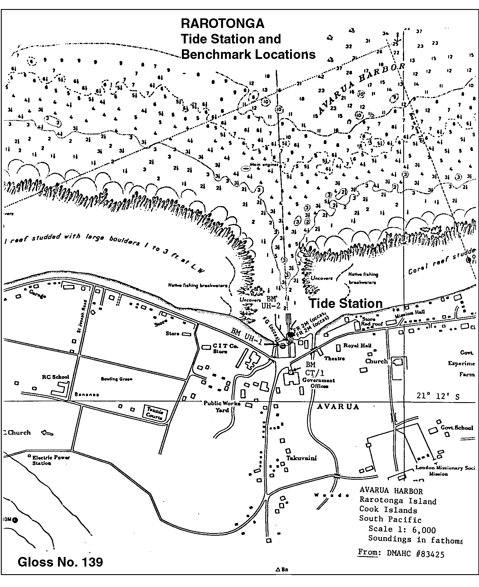
| Tide gauge benchmark | CT/1: triangular stamp (steel pin) with '1' at centre of concrete emplacement; located across street from tide house in parking area of courtyard of govt house near flagpole. Fixed within island wide survey. |
| Auxiliary benchmarks | UH-1: SS pin in concrete emplaced about 10ft W of tide staff at edge of quay, about 2ft from water on cement slab, which seems to be sinking. UH-2: 1 inch SS disc, no stamp, emplaced in concrete about 10ft E of tide staff on finger pier. Not locatable in Feb. 1992 - destroyed. UH-4: 1 inch square SS on top of pin set in white epoxy in cement, located near the closest corner of bldg to right, facing away from sea. |
| Data at PSMSL | |
| Annual MSL (RLR) data | RLR 1843 RLR 1453 |
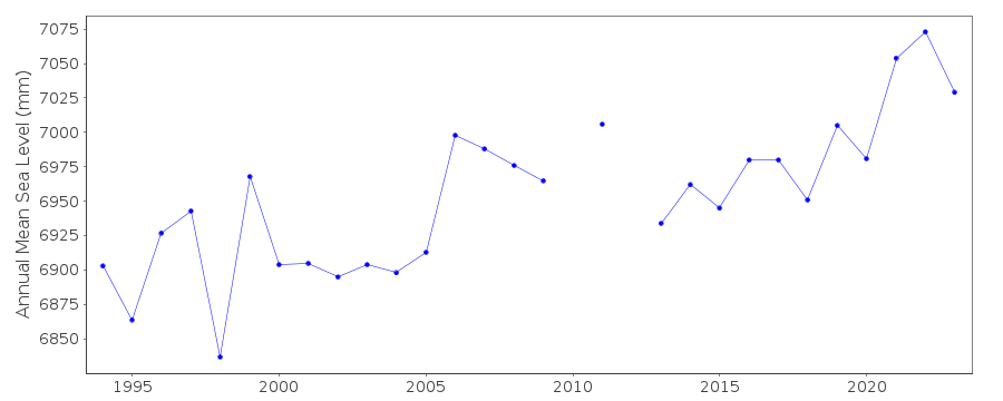
| Annual MSL (RLR) plot | |
| MSL method | Hourly means |
| PSMSL code | 1843 |
| Other relevant codes | NTF port no. 65980, UHSLC 023 |
| Additional information | |
| Other relevant information | Backup gauges on site: 1) Leupold Stevens ADR (December 1984-) 2) Handar encoder ADR (December 1984-) Daily values calculated using 119-point convolution filter (Bloomfield, 1976) centred on noon applied to the hourly data with respective periods of the 95, 50 and 5% amplitude points at 124.0, 60.2 and 40.2 hours. |
| Last updated | 16 October 2002 |
Location map
Rarotonga, Cook Islands
Real time data plot
Rarotonga, Cook Islands
Real time data plot
Rarotonga, Cook Islands
