GLOSS Station Handbook – Chuuk Atoll, Caroline Is.
The GLOSS Station Handbook is currently being re-designed and upgraded.
Until a new version is available, the tide gauge station list below from the last version of the Handbook provides links to further details about each tide gauge in the GLOSS Core Network. Click column headings to sort the station list table. Click the GLOSS number buttons to view the station information.
Station information
| General | |
|---|---|
| Gloss number | 116 |
| Station name | Chuuk Atoll, Caroline Is. |
| Country | Fed. Micronesia |
| Time zone | 150E, GMT + 10hrs |
| Latitude (+ve N) | 7.45 |
| Longitude (+ve E) | 151.85 |
| Ocean | Pacific |
| Observation periods | 1953- |
| Responsible country | U.S.A. |
| Authority responsible for tide gauge | NOAA, National Ocean Service, 1305 East-West Highway, Silver Spring, MD 20910-3281, USA |
| GLOSS contact | Micronesia |
| Committed to GLOSS | Yes |
| Operational | Yes |
| Location map | |
| Instrumentation | |
| Float | No |
| Pressure | No |
| Bubbler | Yes |
| Acoustic | No |
| Radar | No |
| Data | |
| Digital data | Yes |
| Additional parameters | Surface temperature, density |
| Data acquisition rate | Digital gauge - 6 minute interval (after 1975) Analog gauge - hourly heights (before 1975) |
| High frequency data at BODC | Data 116 Document 57437 |
| High frequency data at UHSLC | Data 054a Document 054a File format |
| Real-time data available | Yes |
| Additional parameters (real-time) | None |
| Benchmarks | |
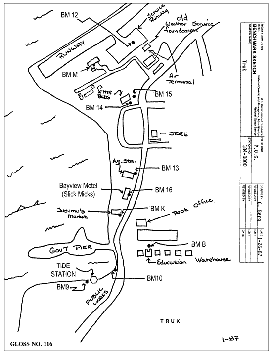
| Tide gauge benchmark | Benchmark B(1948) is the primary benchmark stamped 'B 1948' set in concrete pavement along the north side of a row of 6 Quonset warehouses east of the government pier. |
| Benchmark relationships | Tide Gauge Benchmark is 8.05ft above the Tide Gauge Zero (Station Datum). NOAA Chart Datum is 2.73ft above Station Datum. Mean Sea Level (1960-1978) is 3.58ft above Station Datum. |
| Auxiliary benchmarks | 5 additional benchmarks are levelled to the TGBM and tide station on a yearly basis |
| Data at PSMSL | |
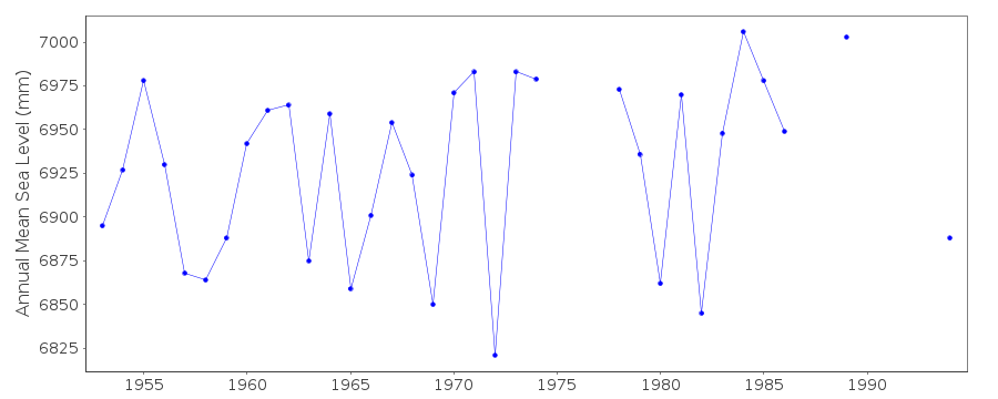
| Annual MSL (RLR) data | RLR 528 |
| Annual MSL (RLR) plot | |
| PSMSL code | 528 |
| Other relevant codes | UHSLC 054 |
| Additional information | |
| Last updated | 11 December 2002 |
Location map
Chuuk Atoll, Caroline Is., Fed. Micronesia
Real time data plot
Chuuk Atoll, Caroline Is., Fed. Micronesia