GLOSS Station Handbook – Tarawa, Gilbert Is.
The GLOSS Station Handbook is currently being re-designed and upgraded.
Until a new version is available, the tide gauge station list below from the last version of the Handbook provides links to further details about each tide gauge in the GLOSS Core Network. Click column headings to sort the station list table. Click the GLOSS number buttons to view the station information.
Station information
| General | |
|---|---|
| Gloss number | 113 |
| Station name | Tarawa, Gilbert Is. |
| Country | Kiribati |
| Time zone | 180E, GMT + 12hrs |
| Latitude (+ve N) | 1.36333 |
| Longitude (+ve E) | 172.93 |
| Ocean | Pacific |
| Observation periods | A: 1974-1983 B: 1983-1988 C: 1988-1997 D: 1992- |
| Responsible country | Australia |
| Authority responsible for tide gauge | National Tidal Centre, Australia (see GLOSS Contact Points). |
| GLOSS contact | Australia |
| Committed to GLOSS | Yes |
| Operational | Yes |
| Instrumentation | |
| Float | Yes |
| Pressure | No |
| Bubbler | No |
| Acoustic | Yes |
| Radar | No |
| Data | |
| Digital data | Yes |
| Data acquisition rate | 15 minute interval, filtered to hourly values |
| Fast delivery data at UHSLC | Data 002 File format |
| High frequency data at BODC | Data 113a Data 113b Data 113c Document 77230 Document 57161 Document 57175 Document 57189 |
| High frequency data at UHSLC | Data 002a Data 002b Data 002c Data 002d Document 002a Document 002b Document 002c Document 002d File format |
| Real-time data available | Yes |
| Real-time data transmitted to GLOSS Fast Centre | |
| Additional parameters (real-time) | None |
| Benchmarks | |
| Tide gauge benchmark | BM1: SS bolt, no stamp, embedded in the concrete curb of the bulkhead directly above the tide staff (about 6ft west of the jetty) (established December 1987) |
| Auxiliary benchmarks | BM2: SS bolt, no stamp, embedded in the concrete foundation of the memorial on the corner facing the jetty (established Dec 1987) BM3: SS bolt, no stamp, embedded in the centre (4th) concrete buttress of the freezer plant wall which faces towards the lagoon BM4: SS bolt, no stamp, embedded in the concrete foundation of the ice plant at the SW corner, facing the channel into the boat harbour |
| Data at PSMSL | |
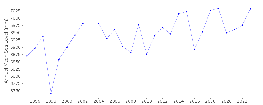
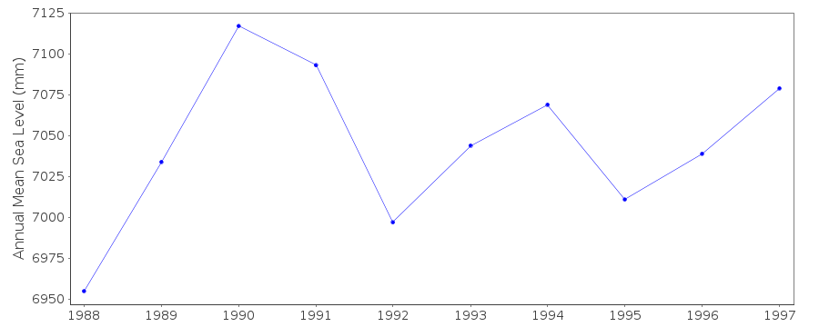
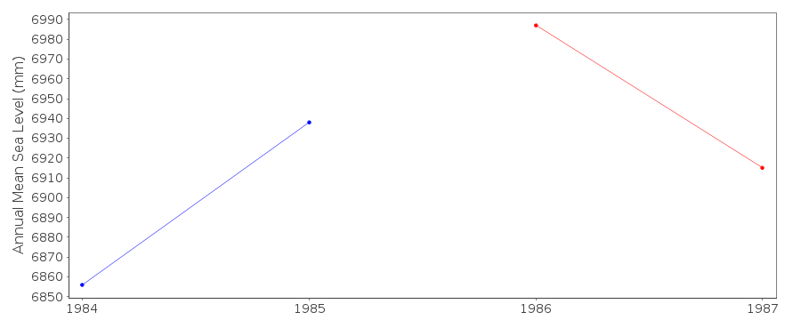
| Annual MSL (RLR) data | RLR 1739 RLR 1579 RLR 1381 RLR 1804 |
| Annual MSL (RLR) plot | |
| MSL method | average of daily values |
| PSMSL code | 1804 |
| Other relevant codes | UHSLC 002 |
| Additional information | |
| Other relevant information | Gauge located at 01deg 20N, 173deg 01E, 1973 - 1987 (Bairiki) Gauge relocated to original location January 1988 (Betio) Site A: PSMSL ref 730/006 Site B: PSMSL ref 730/007 Backup gauge at present site: Handar encoder Additional benchmark, BM5: SS bolt embedded in the concrete porch on the SW corner of the National Fishing Company building, established Dec. 1990 An Aquatrak acoustic gauge was installed in 1992, at a slightly different location to the previous tide gauge. |
| Last updated | 30 January 2007 |
Real time data plot
Tarawa, Gilbert Is., Kiribati
Real time data plot
Tarawa, Gilbert Is., Kiribati
Real time data plot
Tarawa, Gilbert Is., Kiribati

Real time data plot
Tarawa, Gilbert Is., Kiribati