GLOSS Station Handbook – Majuro
The GLOSS Station Handbook is currently being re-designed and upgraded.
Until a new version is available, the tide gauge station list below from the last version of the Handbook provides links to further details about each tide gauge in the GLOSS Core Network. Click column headings to sort the station list table. Click the GLOSS number buttons to view the station information.
Station information
| General | |
|---|---|
| Gloss number | 112 |
| Station name | Majuro |
| Country | Marshall Is. |
| Time zone | 180E, GMT + 12hrs |
| Latitude (+ve N) | 7.1 |
| Longitude (+ve E) | 171.36666 |
| Ocean | Pacific |
| Observation periods | 1975- |
| Responsible country | U.S.A. |
| Authority responsible for tide gauge | Dr. M. Merrifield, University of Hawaii, Dept. of Oceanography, 1000 Pope Road MSB 307, Honolulu, Hawaii 96822, U.S.A. |
| GLOSS contact | USA |
| Committed to GLOSS | Yes |
| Operational | Yes |
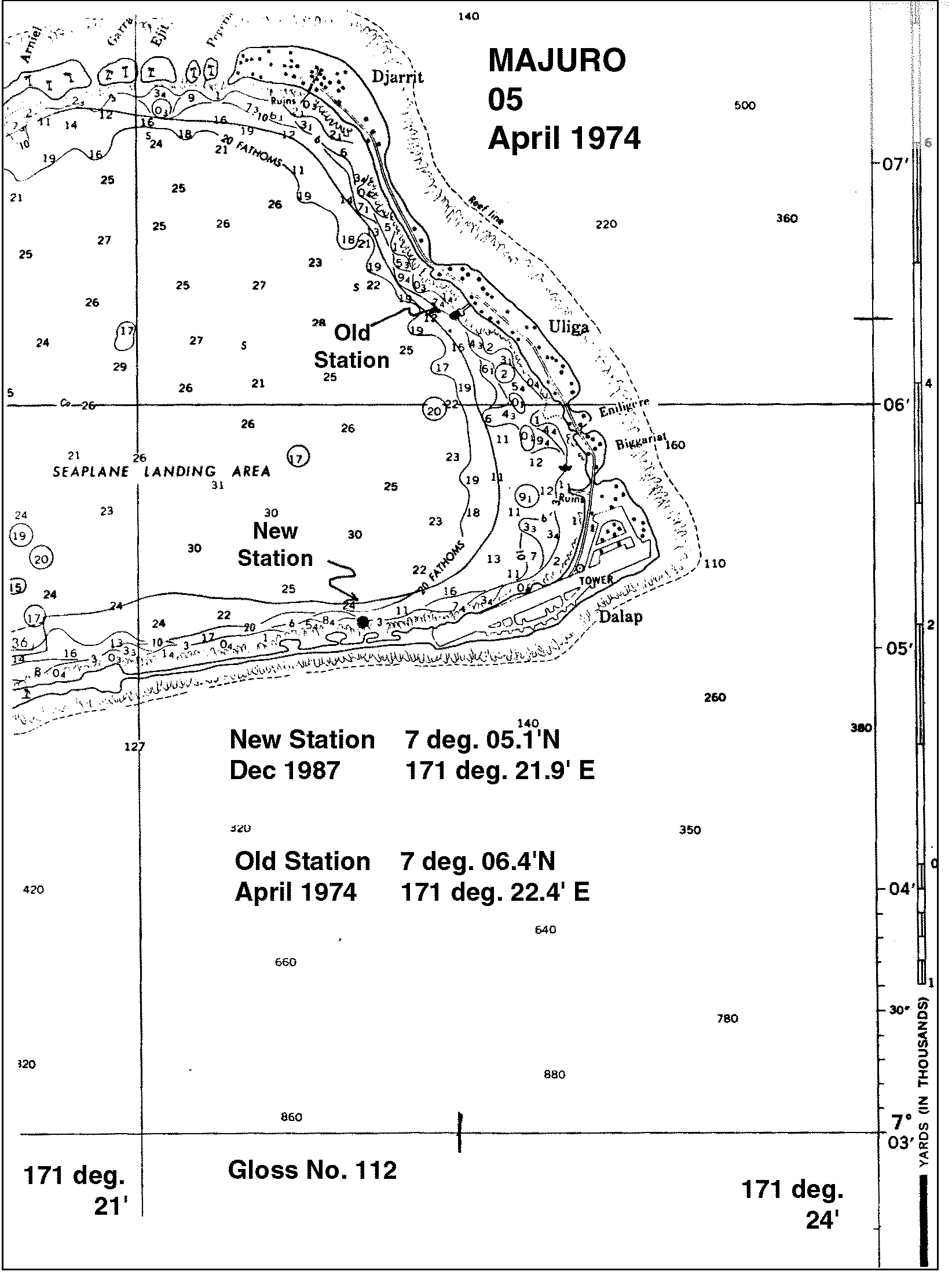
| Location map | |
| Instrumentation | |
| Float | Yes |
| Pressure | No |
| Bubbler | No |
| Acoustic | No |
| Radar | No |
| Data | |
| Digital data | Yes |
| Data acquisition rate | 15 minute intervals, filtered to hourly values |
| Fast delivery data at UHSLC | Data 005 File format |
| High frequency data at BODC | Data 112 Document 77230 Document 57222 |
| High frequency data at UHSLC | Data 005a Data 005b Document 005a Document 005b File format |
| Real-time data available | Yes |
| Real-time data transmitted to GLOSS Fast Centre | |
| Additional parameters (real-time) | None |
| Benchmarks | |
| Tide gauge benchmark | BM1 SS bolt, no stamp, embedded in the concrete roadway to the dock next to the curb about 2 ft south of tide station foundation |
| Auxiliary benchmarks | BM2:SS bolt embedded in the corner of the concrete slab by electrical vault which is on the NW side of the freezer of fishery pier. BM4:SS bolt, no stamp, embedded in concrete curb of the copra dock road way at the top of the incline just past the power station pump house. BM3A: replaces BM3, on rise near the guard rail at SW corner of freezer plant, 5ft from BM3. |
| Data at PSMSL | |
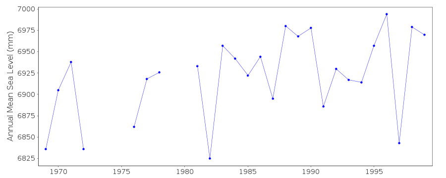
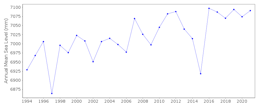
| Annual MSL (RLR) data | RLR 1838 RLR 1217 |
| Annual MSL (RLR) plot | |
| MSL method | average of daily values |
| PSMSL code | 1838 |
| Other relevant codes | UHSLC 005 |
| Additional information | |
| Other relevant information | Backup gauge on site: Handar encoder (August 1983-). Daily values calculated using 119-point convolution filter (Bloomfield, 1976) centred on noon applied to the hourly data with respective periods of the 95, 50 and 5% amplitude points at 124.0, 60.2 and 40.2 hours. |
| Last updated | 5 December 1993 |
Location map
Majuro, Marshall Is.
Real time data plot
Majuro, Marshall Is.
Real time data plot
Majuro, Marshall Is.