GLOSS Station Handbook – Wake Is., Marshall Is.
The GLOSS Station Handbook is currently being re-designed and upgraded.
Until a new version is available, the tide gauge station list below from the last version of the Handbook provides links to further details about each tide gauge in the GLOSS Core Network. Click column headings to sort the station list table. Click the GLOSS number buttons to view the station information.
Station information
| General | |
|---|---|
| Gloss number | 105 |
| Station name | Wake Is., Marshall Is. |
| Country | U.S.A. |
| Time zone | 180E, GMT + 12hrs |
| Latitude (+ve N) | 19.28333 |
| Longitude (+ve E) | 166.61666 |
| Ocean | Pacific |
| Observation periods | 1950-, being upgraded 2007 |
| Responsible country | U.S.A. |
| Authority responsible for tide gauge | NOAA, National Ocean Service, 1305 East-West Highway, Silver Spring, MD 20910-3281, USA |
| GLOSS contact | USA |
| Committed to GLOSS | Yes |
| Operational | Yes |
| Location map | |
| Instrumentation | |
| Float | Yes |
| Pressure | Yes |
| Bubbler | Yes |
| Acoustic | Yes |
| Radar | No |
| Data | |
| Digital data | Yes |
| Additional parameters | Surface temperature, density, barometric pressure |
| Data acquisition rate | Digital gauge - 6 minute intervals (after 1975) Analog gauge - hourly heights (before 1975) |
| Fast delivery data at UHSLC | Data 051 File format |
| High frequency data at BODC | Data 105 Document 57406 |
| High frequency data at UHSLC | Data 051a Document 051a File format |
| Data held at national organisation | Yes |
| Real-time data available | Yes |
| Real-time data transmitted to GLOSS Fast Centre | |
| Additional parameters (real-time) | None |
| Benchmarks | |
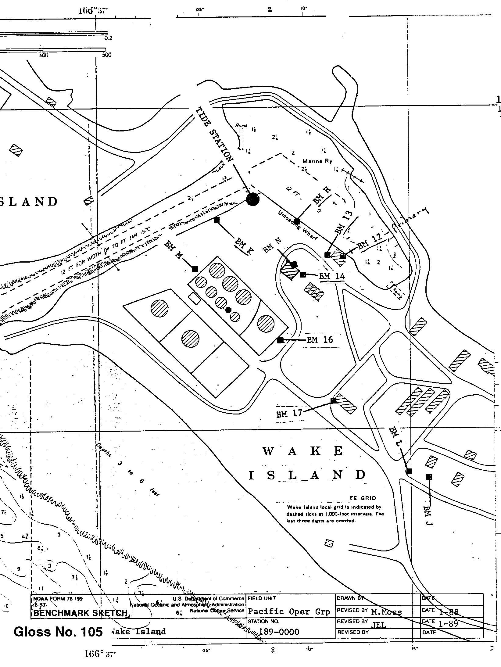
| Tide gauge benchmark | Benchmark 12(1961) is the primary benchmark stamped 'NO 12 1961' set in the concrete apron at the east front corner of the Federal Aviation Administration Boat House |
| Benchmark relationships | TGBM is 14.28ft above Tide Gauge Zero (Station Datum) NOAA Chart Datum is 3.94ft above Station Datum Mean Sea Level (1960-1978) is 5.11ft above Station Datum |
| Auxiliary benchmarks | 8 additional benchmarks are levelled to the TGBM and to the Tide Stationon a yearly basis (BM P, BM L, BM J, BM 17, BM N, BM 13, BM H, BM K). Site inspection 1993 states 'levels agree with history'. BM Q destroyed in typhoon OMAR. |
| Data at PSMSL | |
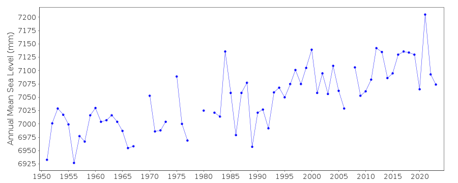
| Annual MSL (RLR) data | RLR 595 |
| Annual MSL (RLR) plot | |
| PSMSL code | 595 |
| Other relevant codes | UHSLC 051 |
| Additional information | |
| Last updated | 5 December 1993 |
Location map
Wake Is., Marshall Is., U.S.A.
Real time data plot
Wake Is., Marshall Is., U.S.A.