GLOSS Station Handbook – Unalaska, Aleutian Is. AK
The GLOSS Station Handbook is currently being re-designed and upgraded.
Until a new version is available, the tide gauge station list below from the last version of the Handbook provides links to further details about each tide gauge in the GLOSS Core Network. Click column headings to sort the station list table. Click the GLOSS number buttons to view the station information.
Station information
| General | |
|---|---|
| Gloss number | 102 |
| Station name | Unalaska, Aleutian Is. AK |
| Country | U.S.A. |
| Time zone | 135W, GMT - 9hrs |
| Latitude (+ve N) | 53.88333 |
| Longitude (+ve E) | -166.53333 |
| Ocean | Pacific |
| Observation periods | 1955-1977, 1982-, being upgraded 2007 |
| Responsible country | U.S.A. |
| Authority responsible for tide gauge | NOAA, National Ocean Service, 1305 East-West Highway, Silver Spring, MD 20910-3281, USA |
| GLOSS contact | USA |
| Committed to GLOSS | Yes |
| Operational | Yes |
| Location map | |
| Instrumentation | |
| Float | Yes |
| Pressure | Yes |
| Bubbler | Yes |
| Acoustic | Yes |
| Radar | No |
| Data | |
| Digital data | Yes |
| Data acquisition rate | 6 minute interval |
| Fast delivery data at UHSLC | Data 041 File format |
| High frequency data at UHSLC | Data 041a Data 041b Document 041a Document 041b File format |
| Data held at national organisation | Yes |
| Real-time data available | Yes |
| Real-time data transmitted to GLOSS Fast Centre | |
| Additional parameters (real-time) | None |
| Benchmarks | |
| Tide gauge benchmark | US C&GS benchmark survey disk stamped 'NO 7 1956' set in a concrete footing of an old antenna near the Alaska Communication System Building. |
| Benchmark relationships | TGBM = 8.78 feet above mean lower low water (1960-1978 epoch) TGBM = 6.59 feet above mean sea level (1960-1978epoch) TGBM = 5.05 feet above mean higher high water (1960-1978 epoch) |
| Auxiliary benchmarks | NO 18 1973 2620 L 1982 NO 19 1973 2620 M 1982 NO 20 1974 TIDAL BM 21 1975 Site inspection 1993 states 2620 J 1979 'levels agree with history' 2620 K 1982 |
| Data at PSMSL | |
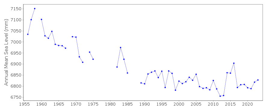
| Annual MSL (RLR) data | RLR 757 |
| Annual MSL (RLR) plot | |
| PSMSL code | 757 |
| Other relevant codes | UHSLC 041 |
| Additional information | |
| Last updated | 5 December 1993 |
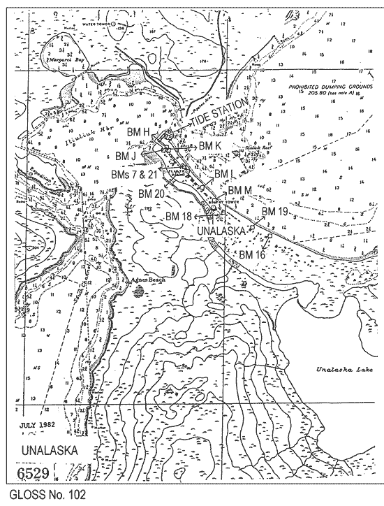
Location map
Unalaska, Aleutian Is. AK, U.S.A.
Real time data plot
Unalaska, Aleutian Is. AK, U.S.A.